Арыгінальны файл(1 545 × 1 242 кропак, аб’ём файла: 187 KB, тып MIME: image/gif, закальцаваныя, 14 кадраў, 44 s)

Гэты файл з на Вікісховішчы і можа выкарыстоўвацца іншымі праектамі. Апісанне на яго старонцы ў Wikimedia Commons прыведзена ніжэй.

This image could be re-created using vector graphics as an SVG file. This has several advantages; see Commons:Media for cleanup for more information. If an SVG form of this image is available, please upload it and afterwards replace this template with {{vector version available|new image name}}. It is recommended to name the SVG file "Breakup of Yugoslavia.svg" - then the template Vector version available (or Vva) does not need the new image name parameter.

Тлумачэнне

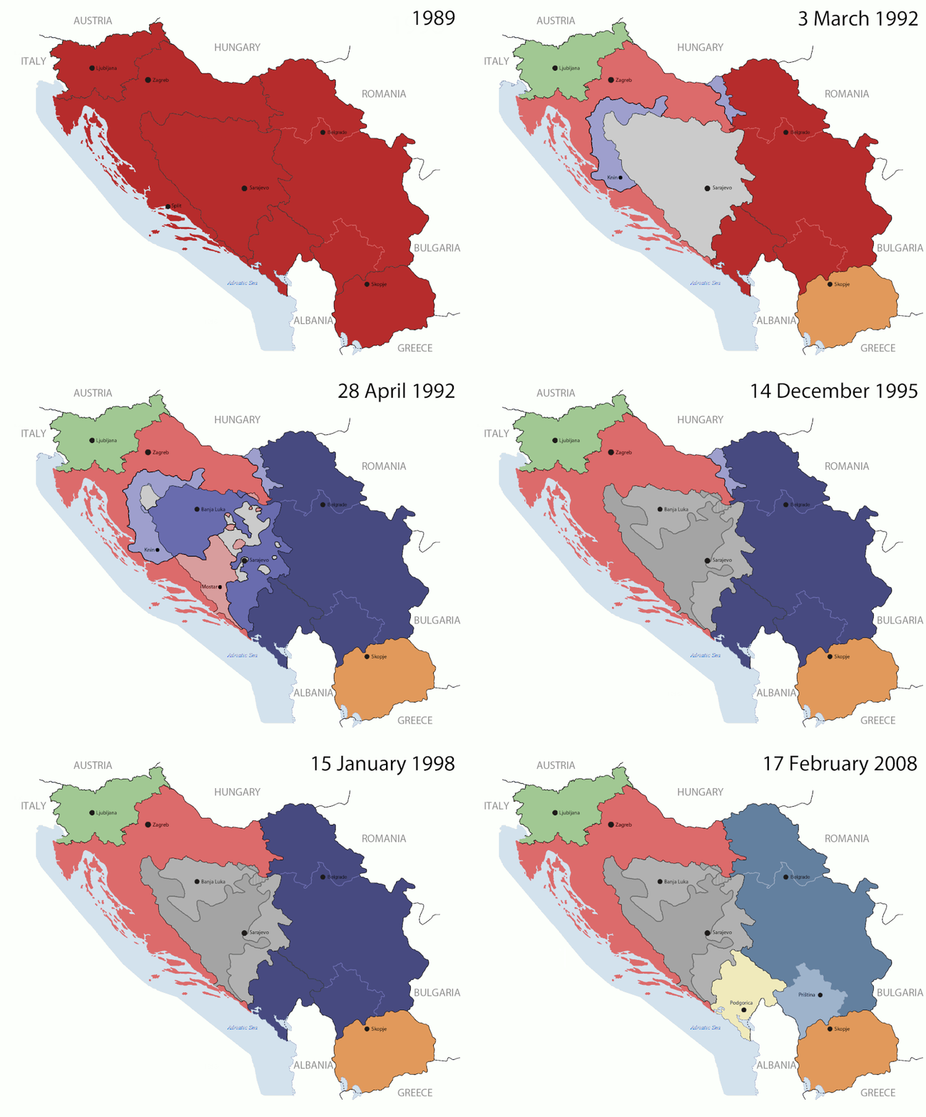
Key:

Yugoslavia (1943–1992) SFR Yugoslavia
Croatia (1991–present) Croatia
Herzeg-Bosnia (1992–1994)
UNTAES (1996–1998)
Federal Republic of Yugoslavia / Serbia and Montenegro (1992–2006) Serbia and Montenegro
Republika Srpska (1992–present) Republika Srpska
Serbian Krajina (1991–1995/96)
Republic of Bosnia and Herzegovina (1992–1995)
Bosnia and Herzegovina (1998–present) Bosnia and Herzegovina
Western Bosnia (1993–1995)
Serbia (2006–present) Serbia
Kosovo (under UNMIK control 1999–present; declaration of independence 2008) Kosovo
Montenegro (2006–present) Montenegro
Macedonia (1991–present) Macedonia
Slovenia (1991–present) Slovenia


Апісанне

This is an animated GIF that shows the stages of the breakup of the SFR Yugoslavia in the 90's and 2000's. The map based off Morwen's map of the divisions of the SFRY, Which is licensed by the GFDL. The source for the dates of independence is the CIA World Factbook. These maps do not now show the Inter-Entity Boundary Line (IEBL) and/or the entities that are separated by it. The IEBL has been drawn based on this CIA map; the Brčko District has been drawn based on Image:BH municipality location.gif, by user:Ante Perkovic. I might add them in the future.

Since the original map was GFDL, this image is as well.

A map depicting Kosovo's final status is ready once it takes effect.


Changelog for versions 2/3:

Here are some changes in this new build of the map:

  • The Kosovo boundary has been given a shade of red instead of the previous UN blue since they are a province of Serbia under UNIMIK control.
  • Montenegro's color has been changed to a golden shade close to what's on the flag.
  • The IEBL and the Brčko District has been redrawn because I deleted the original map; the color for the Republika Srpska is lighter.
  • The dates are at the top left hand corner of the map instead of the bottom.
  • I have taken a new approach as to the boundaries. Each part of Yugoslavia now shows the boundary on the maps starting the year they broke away. I feel this change helps readers understand the breakup better.
  • The SFRY and the FRY are in different shades since the FRY was never accepted as the successor to the former by the UN.
  • The colors for the entities of BiH have been removed as to not confuse people into thinking that they are independent states. What remains is the IEBL with both entities in green.
  • The Kosovo boundary is finally in hash marks!
  • The Brčko District has been removed. The sale is too small to show accurately.

Changelog for version 4:

  • The map is larger!
  • The image has been rebuilt to include the eastern part of FYR Macedonia.
  • The image has been updated to take in Kosovo's new status.
  • The IEBL is now a darker line.
  • Montenegro, Kosovo, and FRY/SCG/Serbia have new colors!

Changelog for version 5:

  • Rebuilt
  • Larger map: size of base image
  • Accurate Inter-Entity Boundary Line
Дата 24 July 2006 (orginal upload date)
Крыніца Made by Hoshie; see above for more details on sources.
Аўтар Hoshie
Іншыя версіі

Ліцэнзіяванне

GNU head Дазваляецца капіяваць, распаўсюджваць і(або) мадыфікаваць гэты дакумент на ўмовах ліцэнзіі GNU FDL версіі 1.2 або навейшай, выдадзенай Фондам свабоднага праграмнага забеспячэння; без Нязменных раздзелаў, без тэкстаў Вокладак. Копія ліцэнзіі ёсць у раздзеле GNU Free Documentation License.
w:en:Creative Commons
атрыбуцыя распаўсюджванне на тых жа ўмовах
Гэты файл даступны па ліцэнзіі Creative Commons Пазначэнне аўтарства - На тых самых умовах 3.0 Непартаваная
Вы можаце свабодна:
  • дзяліцца творам – капіраваць, распаўсюджваць і перадаваць гэты твор.
  • ствараць вытворныя творы – адаптаваць гэты твор
Пры выкананні наступных умоў:
  • атрыбуцыя – вы павінны пазначыць аўтарства гэтага твора, даць спасылку на ліцэнзію і пазначыць ці рабіў аўтар якія-небудзь змены. Гэта можна рабіць кожным зразумелым чынам, але не так, каб наводзіць па думку, што ліцэнзіят падтрымлівае вас або выкарыстанне вамі гэтага твора.
  • распаўсюджванне на тых жа ўмовах – Калі вы змяняеце, адаптуеце ці ствараеце вытворны твор на аснове гэтага, то павінны распаўсюджваць атрыманы ў выніку твор на ўмовах такой самай ці сумяшчальнай ліцэнзіі, што і арыгінал.
Гэтая картка дададзеная ў якасці часткі абнаўлення ліцэнзіі GFDL.

Назвы

Апішыце ў адным радку, што ўяўляе сабой гэты файл

Элементы, адлюстраваныя на гэтым файле

адлюстроўвае

image/gif

checksum англійская

05ca2aefea8406b809968643552d5095c847a42f

метад вызначэння: SHA-1 англійская

191 625 байт

44 секунда

1 242 піксель

1 545 піксель

Гісторыя файла

Націснуць на даце з часам, каб паказаць файл, якім ён тады быў.

(найноўшыя | найстарэйшыя) Гл. (10 навейшыя | ) (10 | 20 | 50 | 100 | 250 | 500).
Дата і часДрабніцаПамерыУдзельнікТлумачэнне
актуальн.10:40, 17 ліпеня 2016Драбніца версіі з 10:40, 17 ліпеня 20161 545 × 1 242 (187 KB)מפתח-רשימהReverted to version as of 17:22, 21 August 2015 (UTC)
20:22, 21 жніўня 2015Драбніца версіі з 20:22, 21 жніўня 20151 463 × 1 158 (1,81 MB)BraganzaReverted to version as of 03:57, 19 January 2010
20:22, 21 жніўня 2015Драбніца версіі з 20:22, 21 жніўня 20151 545 × 1 242 (187 KB)BraganzaReverted to version as of 01:02, 19 December 2011
20:15, 21 жніўня 2015Драбніца версіі з 20:15, 21 жніўня 2015120 × 95 (3 KB)Braganza03:57, 19. Jan. 2010
04:02, 19 снежня 2011Драбніца версіі з 04:02, 19 снежня 20111 545 × 1 242 (187 KB)DIREKTORAdded details
21:09, 27 ліпеня 2011Драбніца версіі з 21:09, 27 ліпеня 20111 545 × 1 242 (170 KB)DIREKTORSmall fixes
20:28, 27 ліпеня 2011Драбніца версіі з 20:28, 27 ліпеня 20111 545 × 1 242 (171 KB)DIREKTORAdded UNMIK
19:38, 27 ліпеня 2011Драбніца версіі з 19:38, 27 ліпеня 20111 545 × 1 242 (165 KB)DIREKTORDates for the last two frames.
15:10, 27 ліпеня 2011Драбніца версіі з 15:10, 27 ліпеня 20111 545 × 1 242 (149 KB)DIREKTORLighter shade for country names
19:59, 26 ліпеня 2011Драбніца версіі з 19:59, 26 ліпеня 20111 545 × 1 242 (170 KB)DIREKTORHigher res plus details
(найноўшыя | найстарэйшыя) Гл. (10 навейшыя | ) (10 | 20 | 50 | 100 | 250 | 500).

Глабальнае выкарыстанне файла

Гэты файл выкарыстоўваецца ў наступных вікі:

Паказаць глабальнае выкарыстанне гэтага файла.

Метаданыя