Файл:British Isles.svg

Памер гэтага PNG-прагляду для SVG-файла: 361 × 600 пікселяў. Іншыя разрозненні: 144 × 240 пікселяў | 289 × 480 пікселяў | 462 × 768 пікселяў | 616 × 1 024 пікселяў | 1 232 × 2 048 пікселяў | 1 300 × 2 160 пікселяў.
Арыгінальны файл (файл SVG, намінальна 1 300 × 2 160 кропак, аб’ём файла: 154 KB)
Тлумачэнне
| Апісанне |
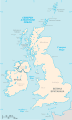
An SVG map of the British Isles, with the largest islands and archipelagos labelled. Always considered part of the British Isles
Sometimes considered part of the British Isles
Other lands |
| Крыніца | Уласная праца |
| Аўтар | Smurrayinchester |
| SVG genesis | Гэты файл (вектарная выява) быў створаны з дапамогай unknown tool. This map is translated using SVG switch elements: all translations are stored in the same file. |
}
Ліцэнзіяванне
Я, уладальнік аўтарскіх правоў на гэты твор, добраахвотна публікую яго на ўмовах наступнай ліцэнзіі:

|
Дазваляецца капіяваць, распаўсюджваць і(або) мадыфікаваць гэты дакумент на ўмовах ліцэнзіі GNU FDL версіі 1.2 або навейшай, выдадзенай Фондам свабоднага праграмнага забеспячэння; без Нязменных раздзелаў, без тэкстаў Вокладак. Копія ліцэнзіі ёсць у раздзеле GNU Free Documentation License. |
| Гэты файл даступны па ліцэнзіі Creative Commons Пазначэнне аўтарства - На тых самых умовах 3.0 Непартаваная | ||
| ||
| Гэтая картка дададзеная ў якасці часткі абнаўлення ліцэнзіі GFDL. |
Derivative works
-
 македонски
 -
 Flag map (1801–1922)


derivative works
Derivative works of this file: British Isles mk.svg
Гісторыя файла
Націснуць на даце з часам, каб паказаць файл, якім ён тады быў.
| Дата і час | Драбніца | Памеры | Удзельнік | Тлумачэнне | |
|---|---|---|---|---|---|
| актуальн. | 18:33, 10 лютага 2019 | | 1 300 × 2 160 (154 KB) | MSG17 | Uploaded from SVG Translate. |
| 17:56, 13 кастрычніка 2018 |  | 1 300 × 2 160 (141 KB) | Seb35 | small bug: translations have to be before the default text else the PNG rendering selects the default text | |
| 17:51, 13 кастрычніка 2018 |  | 1 300 × 2 160 (141 KB) | Seb35 | added French translation | |
| 17:50, 20 мая 2014 |  | 1 300 × 2 160 (135 KB) | NikNaks | More cleaning. File could still be a lot smaller than it currently is | |
| 06:02, 20 мая 2014 |  | 1 300 × 2 160 (152 KB) | NikNaks | Malay translation | |
| 05:36, 20 мая 2014 |  | 1 300 × 2 160 (148 KB) | NikNaks | Cleaning unfortunately lost detail. Will have to return to later | |
| 05:22, 20 мая 2014 |  | 1 297 × 2 160 (37 KB) | NikNaks | Attempting to clean up the file before translation | |
| 15:37, 20 жніўня 2006 |  | 1 297 × 2 160 (196 KB) | Smurrayinchester | An SVG map of the British Isles, with the largest islands and archipelagos labeled. {{legend|#fff0de|Always considered part of the British Isles|border=#ffffff}} {{legend|#ffb380|Sometimes considered part of the British Isles|border=#ffffff}} {{legend|#e |
Выкарыстанне файла
Наступная 1 старонка выкарыстоўвае гэты файл:
Глабальнае выкарыстанне файла
Гэты файл выкарыстоўваецца ў наступных вікі:
- Выкарыстанне ў ar.wikipedia.org
- Выкарыстанне ў az.wikipedia.org
- Выкарыстанне ў bs.wikipedia.org
- Выкарыстанне ў ceb.wikipedia.org
- Выкарыстанне ў ckb.wikipedia.org
- Выкарыстанне ў da.wikipedia.org
- Выкарыстанне ў en.wikipedia.org
- Geography of the Isle of Man
- Burhou
- Talk:International Football Association Board
- Module:Location map/data/British Isles/doc
- List of offshore wind farms in the Irish Sea
- Siege of St Andrews Castle
- User:Malpass93/sandbox
- Module:Location map/data/British Isles
- 2014 Senior Open Championship
- 2017 Senior Open Championship
- 2018 Eisenhower Trophy
- User:Grover cleveland/History of the laws of the game/List of IFAB meetings
- User:Grover cleveland/English managers
- 2018 Espirito Santo Trophy
- 1965 European Amateur Team Championship
- 1975 European Amateur Team Championship
- 1981 European Amateur Team Championship
- 1989 European Amateur Team Championship
- 1997 European Amateur Team Championship
- 2005 European Amateur Team Championship
- 2007 European Amateur Team Championship
- 2009 European Amateur Team Championship
- 1971 European Ladies' Team Championship
- 1979 European Ladies' Team Championship
- 1987 European Ladies' Team Championship
- 1991 European Ladies' Team Championship
- 2013 European Ladies' Team Championship
- 2021 European Ladies' Team Championship
- 2022 European Amateur Team Championship
- 2022 European Ladies' Team Championship
- 2013 Senior Open Championship
- 2012 Senior Open Championship
- 2011 Senior Open Championship
- 2008 Senior Open Championship
- 2006 Senior Open Championship
- 2002 Senior British Open
- 2001 Senior British Open
- 2000 Senior British Open
- 2022 Senior Open Championship
- User:Erik Sergeant/sandbox 2
- 2023 Senior Open Championship
- Module:Location map/data/British Isles/sandbox
- Draft:2024 Monoposto Championship
- Выкарыстанне ў es.wikipedia.org
Паказаць глабальнае выкарыстанне гэтага файла.