Файл:Ragusa.png
Няма версіі з большай раздзяляльнасцю.
Ragusa.png (675 × 354 кропак, аб’ём файла: 128 KB, тып MIME: image/png)
Тлумачэнне
| Апісанне |
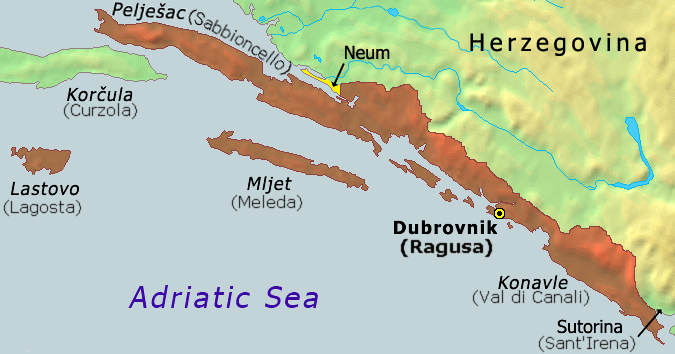
Hrvatski: Karta Dubrovačke republike iz 1808
English: Map of the Republic of Ragusa as of 1808 |
||
| Дата | |||
| Крыніца | Demis Map Server (http://www2.demis.nl/mapserver/mapper.asp) data with additional annotations and modifications by self. | ||
| Аўтар | ChrisO | ||
| Іншыя версіі |
Derivative works of this file: Ragusa-IT.png
|


|
This historical map image could be re-created using vector graphics as an SVG file. This has several advantages; see Commons:Media for cleanup for more information. If an SVG form of this image is available, please upload it and afterwards replace this template with
{{vector version available|new image name}}.
It is recommended to name the SVG file “Ragusa.svg”—then the template Vector version available (or Vva) does not need the new image name parameter. |
Гісторыя файла
Націснуць на даце з часам, каб паказаць файл, якім ён тады быў.
| Дата і час | Драбніца | Памеры | Удзельнік | Тлумачэнне | |
|---|---|---|---|---|---|
| актуальн. | 10:51, 21 кастрычніка 2020 | | 675 × 354 (128 KB) | Claude Zygiel | Ragusan / Venetian names also (official until 1918) |
| 22:49, 6 лютага 2020 |  | 675 × 354 (114 KB) | Ceha | Klek was part of Dubrovnik Republic. Tip of the peninsula is in Croatia, while the rest is in BiH. The same goes for the small island of Lastavica, which is today in Montenegro... https://www.google.com/maps/place/Mamula/@42.3952695,18.4181714,11z/data=!4m5!3m4!1s0x134c24e629d0b6ed:0x1d78b87fc20846b1!8m2!3d42.3954043!4d18.5585609 | |
| 00:15, 9 верасня 2010 |  | 675 × 354 (65 KB) | DIREKTOR | fix | |
| 20:02, 25 лістапада 2006 |  | 675 × 354 (53 KB) | Tieum512 | {{Information |Description=Map of the Republic of Ragusa as of 1808 Based on Demis Web Map Server output |Source=http://en.wikipedia.org/wiki/Image:Ragusa.png |Date= |Author=User:ChrisO |Permission=GFDL |other_versions= }} |
Выкарыстанне файла
Наступная 1 старонка выкарыстоўвае гэты файл:
Глабальнае выкарыстанне файла
Гэты файл выкарыстоўваецца ў наступных вікі:
- Выкарыстанне ў an.wikipedia.org
- Выкарыстанне ў ar.wikipedia.org
- Выкарыстанне ў ast.wikipedia.org
- Выкарыстанне ў azb.wikipedia.org
- Выкарыстанне ў az.wikipedia.org
- Выкарыстанне ў be-tarask.wikipedia.org
- Выкарыстанне ў bg.wikipedia.org
- Выкарыстанне ў br.wikipedia.org
- Выкарыстанне ў bs.wikipedia.org
- Выкарыстанне ў ca.wikipedia.org
- Выкарыстанне ў cs.wikipedia.org
- Выкарыстанне ў da.wikipedia.org
- Выкарыстанне ў de.wikipedia.org
- Выкарыстанне ў el.wikipedia.org
- Выкарыстанне ў en.wikipedia.org
- Выкарыстанне ў eo.wikipedia.org
- Выкарыстанне ў es.wikipedia.org
- Выкарыстанне ў et.wikipedia.org
- Выкарыстанне ў eu.wikipedia.org
- Выкарыстанне ў fa.wikipedia.org
- Выкарыстанне ў fi.wikipedia.org
- Выкарыстанне ў fr.wikipedia.org
- Выкарыстанне ў fy.wikipedia.org
- Выкарыстанне ў gl.wikipedia.org
- Выкарыстанне ў he.wikipedia.org
- Выкарыстанне ў hu.wikipedia.org
- Выкарыстанне ў ia.wikipedia.org
- Выкарыстанне ў id.wikipedia.org
- Выкарыстанне ў ie.wikipedia.org
- Выкарыстанне ў it.wikipedia.org
- Выкарыстанне ў ja.wikipedia.org
- Выкарыстанне ў ko.wikipedia.org
- Выкарыстанне ў li.wikipedia.org
- Выкарыстанне ў mk.wikipedia.org
- Выкарыстанне ў ms.wikipedia.org
- Выкарыстанне ў mt.wikipedia.org
Паказаць глабальнае выкарыстанне гэтага файла.