Файл:Spread of Christianity to AD 600 - Atlas of World History.png

Памер папярэдняга прагляду: 800 × 592 пікселяў. Іншыя разрозненні: 320 × 237 пікселяў | 640 × 474 пікселяў | 1 024 × 758 пікселяў | 1 280 × 948 пікселяў | 2 187 × 1 619 пікселяў.
Арыгінальны файл (2 187 × 1 619 кропак, аб’ём файла: 227 KB, тып MIME: image/png)
Тлумачэнне
| Апісанне |
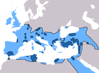
English: Map of the spread of Christianity in Europe, Southwest Asia and North Africa to the year AD 600.
"redominantly Christian by AD 325" zone coloured in dark blue, "Predominantly Christian by AD 600" coloured in light blue.
Predominantly Christian by AD 325
Predominantly Christian by AD 600
Magyar: A kereszténység elterjedése:
Kr. u. 325-ig
325 és 600 között
Information obtained from Patrick O'Brien , ed. (2003) Atlas of World History, Category:New York: Oxford University Press, pp. 44−5 0-19-521921-X Map created and uploaded in the English Wikipedia by Geuiwogbil. Base map: "File:BlankMap-Europe-v3.png" |
| Дата | 27 мая 2009 (original upload date) |
| Крыніца | Transferred from en.wikipedia to Commons by QuartierLatin1968 using CommonsHelper. |
| Аўтар | Geuiwogbil at англійская Вікіпедыя |

|
This religion map image could be re-created using vector graphics as an SVG file. This has several advantages; see Commons:Media for cleanup for more information. If an SVG form of this image is available, please upload it and afterwards replace this template with
{{vector version available|new image name}}.
It is recommended to name the SVG file “Spread of Christianity to AD 600 - Atlas of World History.svg”—then the template Vector version available (or Vva) does not need the new image name parameter. |
Ліцэнзіяванне
Geuiwogbil from en.wikipedia.org, уладальнік аўтарскіх правоў на гэты твор, добраахвотна публікуе яе на ўмовах наступнай ліцэнзіі:
| Гэты файл даступны па ліцэнзіі Creative Commons Пазначэнне аўтарства - На тых самых умовах 3.0 Непартаваная Subject to disclaimers. | ||
| Пазначэнне аўтарства: Geuiwogbil from en.wikipedia.org | ||
| ||
| Гэтая картка дададзеная ў якасці часткі абнаўлення ліцэнзіі GFDL. |

|
Дазваляецца капіяваць, распаўсюджваць і(або) мадыфікаваць гэты дакумент на ўмовах ліцэнзіі GNU FDL версіі 1.2 або навейшай, выдадзенай Фондам свабоднага праграмнага забеспячэння; без Нязменных раздзелаў, без тэкстаў Вокладак. Копія ліцэнзіі ёсць у раздзеле GNU Free Documentation License. Subject to disclaimers. |
Журнал арыгінальнай загрузкі
The original description page was here. All following user names refer to en.wikipedia.
- 2009-05-27 19:20 Carlaude 2187×1619× (232587 bytes) Cutting out unused areas of the map
- 2006-09-09 02:34 Geuiwogbil 2285×2181× (248280 bytes) Blue provides us with a better constrast.
- 2006-09-04 05:10 Geuiwogbil 2285×2181× (254524 bytes)
- 2006-09-04 05:08 Geuiwogbil 2285×2181× (116034 bytes) Map of the spread of Christianity in Europe, Southwest Asia and North Africa to the year 600 AD. Base map "BlankMap-Europe-v.3." Spread of Christianity to AD 325 coloured in orange, to 600 coloured in yellow. Information obtained from {{cite book |editor=
Гісторыя файла
Націснуць на даце з часам, каб паказаць файл, якім ён тады быў.
| Дата і час | Драбніца | Памеры | Удзельнік | Тлумачэнне | |
|---|---|---|---|---|---|
| актуальн. | 20:31, 3 чэрвеня 2022 | | 2 187 × 1 619 (227 KB) | Veverve | Reverted to version as of 10:19, 4 July 2021 (UTC) please bring a map source to counter this claim that only part of Armenia etc. were partially christianised |
| 20:08, 3 чэрвеня 2022 |  | 2 187 × 1 619 (245 KB) | Rs4815 | Reverted to version as of 09:58, 24 February 2013 (UTC) You can't just ignore the fact that the "sourced version of the map" has a blunder. By the year 325, the Armenian kingdom had already been converted to Christianity | |
| 13:19, 4 ліпеня 2021 |  | 2 187 × 1 619 (227 KB) | Veverve | Reverted to version as of 12:31, 9 November 2009 (UTC) revert to what is an actually sourced version of the map | |
| 09:34, 23 мая 2018 |  | 2 187 × 1 619 (213 KB) | Inowen | Add labels for Europe, Africa, and Middle East using Inkscape to import previous and overlay text in svg. | |
| 12:58, 24 лютага 2013 |  | 2 187 × 1 619 (245 KB) | Prince of Nothing05 | Kingdom of Armenia, Iberia and Caucasian Albania had already made Christianity official religion. | |
| 15:31, 9 лістапада 2009 |  | 2 187 × 1 619 (227 KB) | QuartierLatin1968 | {{Information |Description={{en|Map of the spread of Christianity in Europe, Southwest Asia and North Africa to the year 600 AD. Base map "BlankMap-Europe-v.3." Spread of Christianity to AD 325 coloured in light blue, to 600 coloured in dark blue. Informa |
Выкарыстанне файла
Наступныя 2 старонкі выкарыстоўваюць гэты файл:
Глабальнае выкарыстанне файла
Гэты файл выкарыстоўваецца ў наступных вікі:
- Выкарыстанне ў ar.wikipedia.org
- Выкарыстанне ў arz.wikipedia.org
- Выкарыстанне ў bg.wikipedia.org
- Выкарыстанне ў ca.wikipedia.org
- Выкарыстанне ў cs.wikipedia.org
- Выкарыстанне ў de.wikipedia.org
- Выкарыстанне ў el.wikipedia.org
- Выкарыстанне ў en.wikipedia.org
- Christendom
- Christian Church
- Christianity in Africa
- Talk:Christian Church/Archive 1
- Christianity in the Middle East
- Spread of Christianity
- Multiculturalism and Christianity
- Western world
- Christianity in the ante-Nicene period
- Christianity in the 4th century
- Christianity in the 5th century
- Christianity in the 6th century
- Christianity in the 7th century
- Christianity in late antiquity
- Christianity as the Roman state religion
- Roman people
- User:Falcaorib
- Выкарыстанне ў en.wikibooks.org
- Выкарыстанне ў en.wikiquote.org
- Выкарыстанне ў eo.wikipedia.org
- Выкарыстанне ў es.wikipedia.org
Паказаць глабальнае выкарыстанне гэтага файла.