Файл:Wfm firth of forth.jpg

Памер папярэдняга прагляду: 800 × 593 пікселяў. Іншыя разрозненні: 320 × 237 пікселяў | 640 × 474 пікселяў | 1 024 × 758 пікселяў | 1 280 × 948 пікселяў.
Арыгінальны файл (1 280 × 948 кропак, аб’ём файла: 289 KB, тып MIME: image/jpeg)
Тлумачэнне
| Апісанне |
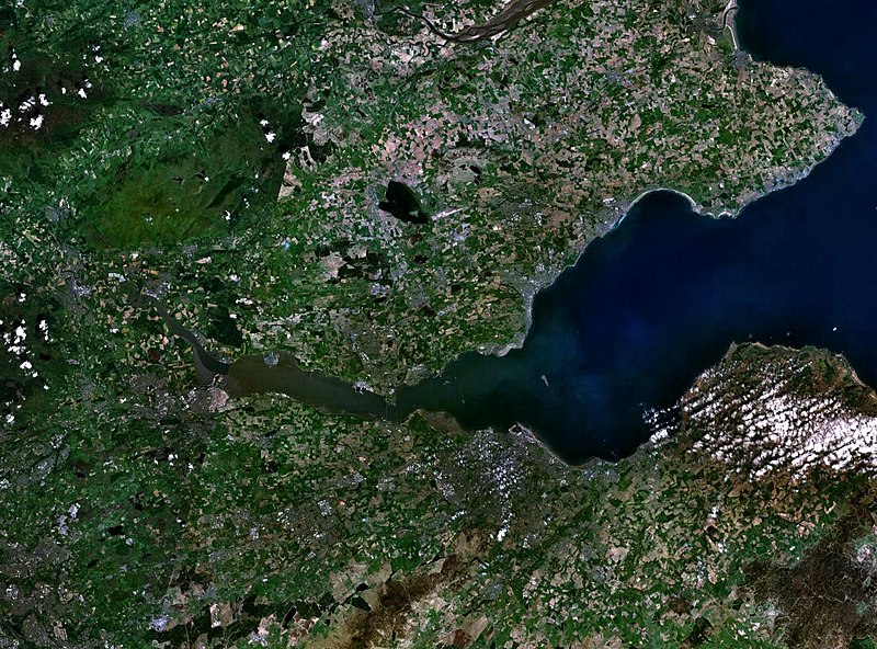
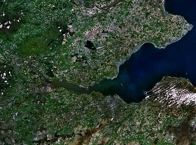
English: The Firth of the river Forth, on the east coast of Scotland. The two forth bridges are visible near the centre of the frame. Stirling is at the extreme left side. |
| Дата | 3 жніўня 2005 (upload date) |
| Крыніца | Satellite imagery taken by screenshot from NASA World Wind software |
| Аўтар | NASA |
Ліцэнзіяванне
| This image is in the public domain because it is a screenshot from NASA’s globe software World Wind using a public domain layer, such as Blue Marble, MODIS, Landsat, SRTM, USGS or GLOBE.
|
 |
Гісторыя файла
Націснуць на даце з часам, каб паказаць файл, якім ён тады быў.
| Дата і час | Драбніца | Памеры | Удзельнік | Тлумачэнне | |
|---|---|---|---|---|---|
| актуальн. | 12:38, 3 жніўня 2005 | | 1 280 × 948 (289 KB) | Finlay McWalter | The Firth of the river Forth, on the east coast of Scotland. The two forth bridges are visible near the centre of the frame. Stirling is at the extreme left side. Image made with NASA World Wind. {{PD-USGov-NASA}} category:satellite photos |
Выкарыстанне файла
Наступная 1 старонка выкарыстоўвае гэты файл:
Глабальнае выкарыстанне файла
Гэты файл выкарыстоўваецца ў наступных вікі:
- Выкарыстанне ў ar.wikipedia.org
- Выкарыстанне ў bg.wikipedia.org
- Выкарыстанне ў br.wikipedia.org
- Выкарыстанне ў ca.wikipedia.org
- Выкарыстанне ў ceb.wikipedia.org
- Выкарыстанне ў cs.wikipedia.org
- Выкарыстанне ў cy.wikipedia.org
- Выкарыстанне ў de.wikipedia.org
- Выкарыстанне ў el.wikipedia.org
- Выкарыстанне ў en.wikipedia.org
- Выкарыстанне ў en.wikivoyage.org
- Выкарыстанне ў eo.wikipedia.org
- Выкарыстанне ў es.wikipedia.org
- Выкарыстанне ў et.wikipedia.org
- Выкарыстанне ў eu.wikipedia.org
- Выкарыстанне ў fa.wikipedia.org
- Выкарыстанне ў fr.wikipedia.org
- Выкарыстанне ў ga.wikipedia.org
- Выкарыстанне ў gd.wikipedia.org
- Выкарыстанне ў ha.wikipedia.org
- Выкарыстанне ў he.wikipedia.org
- Выкарыстанне ў hi.wikipedia.org
- Выкарыстанне ў ia.wikipedia.org
- Выкарыстанне ў is.wikipedia.org
- Выкарыстанне ў it.wikipedia.org
- Выкарыстанне ў it.wikivoyage.org
- Выкарыстанне ў ja.wikipedia.org
- Выкарыстанне ў kbd.wikipedia.org
- Выкарыстанне ў lt.wikipedia.org
- Выкарыстанне ў mt.wikipedia.org
- Выкарыстанне ў nl.wikipedia.org
- Выкарыстанне ў nn.wikipedia.org
- Выкарыстанне ў no.wikipedia.org
- Выкарыстанне ў pl.wikipedia.org
- Выкарыстанне ў pt.wikipedia.org
- Выкарыстанне ў ro.wikipedia.org
- Выкарыстанне ў ru.wikipedia.org
- Выкарыстанне ў sco.wikipedia.org
Паказаць глабальнае выкарыстанне гэтага файла.