Файл:British isles 802.jpg
Памер папярэдняга прагляду: 572 × 599 пікселяў. Іншыя разрозненні: 229 × 240 пікселяў | 458 × 480 пікселяў | 733 × 768 пікселяў | 1 076 × 1 127 пікселяў.
Арыгінальны файл (1 076 × 1 127 кропак, аб’ём файла: 1,29 MB, тып MIME: image/jpeg)
Тлумачэнне
| Апісанне |
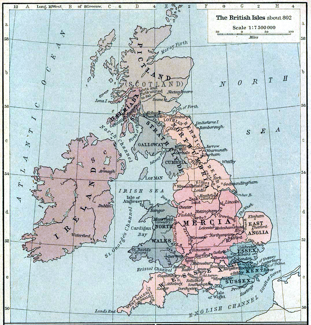
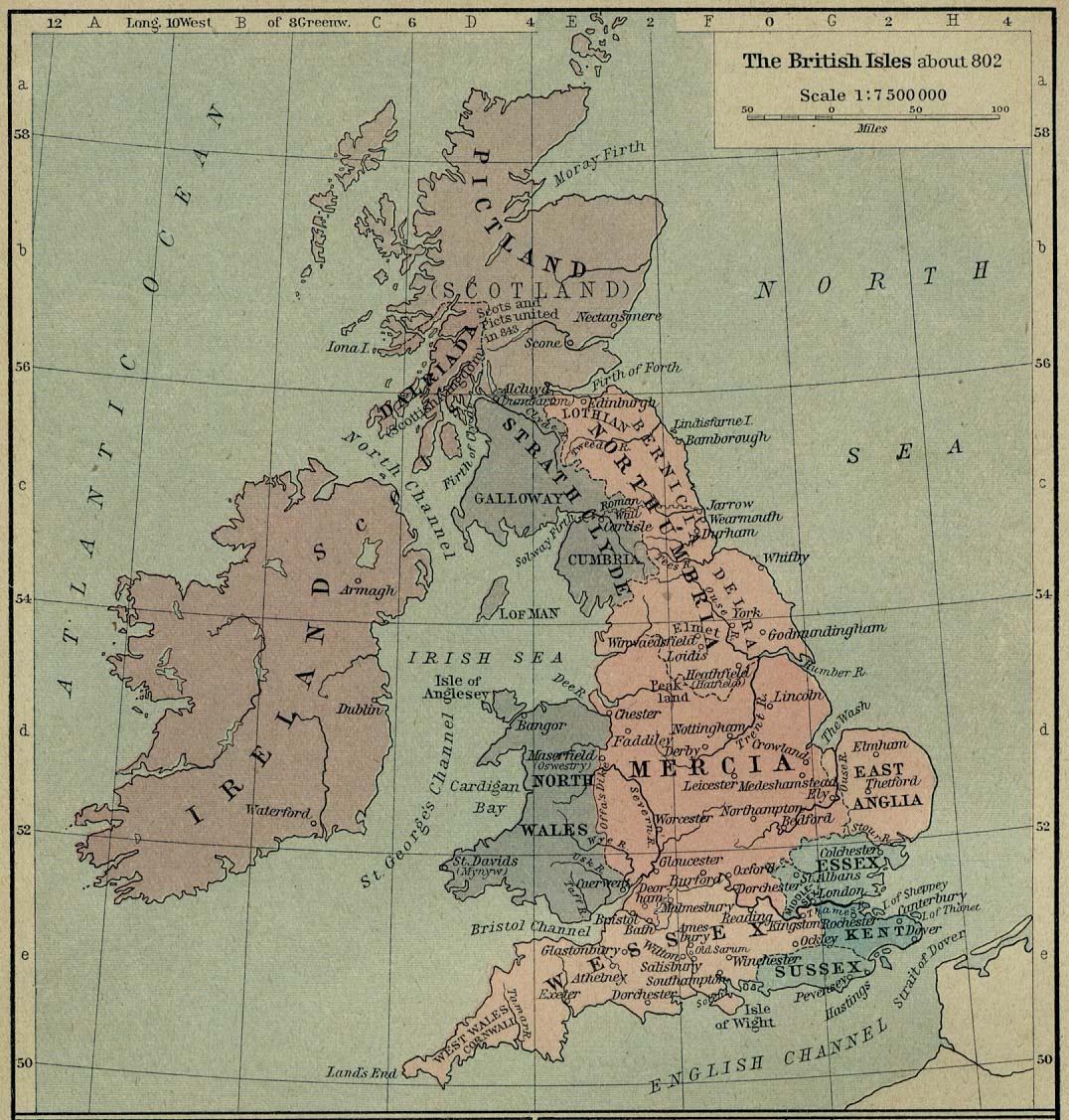
English: Map of the British Isles claiming to represent borders circa 802 AD. |
||||||||||||||||||||||
| Дата | |||||||||||||||||||||||
| Крыніца | Shepherd, William R. (1926) Historical Atlas, Category:New York: Henry Holt and Company | ||||||||||||||||||||||
| Аўтар |
|
||||||||||||||||||||||
Ліцэнзіяванне
|
The author died in 1934, so this work is in the public domain in its country of origin and other countries and areas where the copyright term is the author's life plus 80 years or fewer. This work is in the public domain in the United States because it was published (or registered with the U.S. Copyright Office) before January 1, 1929. | |
| Гэты файл быў ідэнтыфікаваны як вольны ад вядомых абмежаванняў, згодна з законам аб аўтарскім праве, а таксама ад усіх сумежных правоў. | |
Гісторыя файла
Націснуць на даце з часам, каб паказаць файл, якім ён тады быў.
| Дата і час | Драбніца | Памеры | Удзельнік | Тлумачэнне | |
|---|---|---|---|---|---|
| актуальн. | 00:30, 13 жніўня 2019 | | 1 076 × 1 127 (1,29 MB) | Alphathon | A few more minor tweaks |
| 00:24, 13 жніўня 2019 |  | 1 076 × 1 127 (1,24 MB) | Alphathon | re-did cleaning (using original version) | |
| 21:36, 8 кастрычніка 2006 |  | 1 076 × 1 127 (1,19 MB) | Steinsky | cleaned | |
| 18:47, 3 снежня 2005 |  | 1 076 × 1 127 (273 KB) | Migdejong | Map of the isle Great Brittain in the year 802. Image comes from the University of Texas at Austin: http://geography.about.com/gi/dynamic/offsite.htm?site=http://www.lib.utexas.edu/maps/historical/history%5Feurope.html Map is released into the publi |
Выкарыстанне файла
Наступная 1 старонка выкарыстоўвае гэты файл:
Глабальнае выкарыстанне файла
Гэты файл выкарыстоўваецца ў наступных вікі:
- Выкарыстанне ў be-tarask.wikipedia.org
- Выкарыстанне ў br.wikipedia.org
- Выкарыстанне ў de.wikipedia.org
- Выкарыстанне ў el.wikipedia.org
- Выкарыстанне ў en.wikipedia.org
- List of monarchs of East Anglia
- Talk:East Anglia
- List of monarchs of Wessex
- List of monarchs of Northumbria
- List of monarchs of Mercia
- List of monarchs of Kent
- List of monarchs of Sussex
- History of Cornwall
- Constitutional status of Cornwall
- Talk:Regions of England
- Wikipedia:WikiProject Anglo-Saxon Kingdoms
- User:Amitchell125/listofmonarchsofeastanglia
- Template:Anglo-Saxon kings
- Выкарыстанне ў fr.wikipedia.org
- Выкарыстанне ў gd.wikipedia.org
- Выкарыстанне ў got.wikipedia.org
- Выкарыстанне ў he.wikipedia.org
- Выкарыстанне ў hu.wikipedia.org
- Выкарыстанне ў it.wikipedia.org
Паказаць глабальнае выкарыстанне гэтага файла.