Файл:Cape Town 2011 population density map.svg

Памер гэтага PNG-прагляду для SVG-файла: 405 × 599 пікселяў. Іншыя разрозненні: 162 × 240 пікселяў | 324 × 480 пікселяў | 519 × 768 пікселяў | 692 × 1 024 пікселяў | 1 385 × 2 048 пікселяў | 771 × 1 140 пікселяў.
Арыгінальны файл (файл SVG, намінальна 771 × 1 140 кропак, аб’ём файла: 761 KB)
Тлумачэнне
| Апісанне |
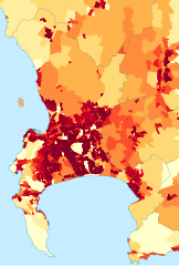
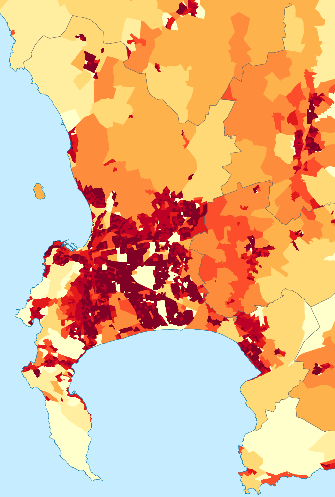
English: Population density map of the City of Cape Town, Western Cape, South Africa, from the 2011 Census, at the "Small Area" level.
<1 inhabitant/km²
1–3 inhabitants/km²
3–10 inhabitants/km²
10–30 inhabitants/km²
30–100 inhabitants/km²
100–300 inhabitants/km²
300–1000 inhabitants/km²
1000–3000 inhabitants/km²
>3000 inhabitants/km² |
| Дата | |
| Крыніца | Statistics South Africa's Census 2011 is the source of the basic population data. The map results from my own processing of the data. |
| Аўтар | Htonl |
| Дазвол (Паўторнае выкарыстанне гэтага файла) |
http://beta2.statssa.gov.za/?page_id=425 |
Ліцэнзіяванне
The following license applies to the population data on which the map is based:
 |
The copyright holder of this file allows anyone to use it
for any purpose, provided that the user acknowledges Stats SA as the source of the basic data wherever they process, apply, utilise, publish or distribute the data, and also that they specify that the relevant application and analysis (where applicable) result from their own processing of the data..
Usage notes:
|
|
Please check that the conditions given above are compliant to the Commons licensing policy. Most importantly, derivative work and commercial use must be allowed.
|
The following tag applies to the map itself:
| Я, уладальнік аўтарскіх правоў на гэты твор, перадаю яго ў грамадскі набытак. Дазвол сапраўдны для ўсяго свету. У некаторых краінах гэта не можа быць юрыдычна магчыма; калі так, то: Я дазваляю кожнаму выкарыстоўваць гэтую працу ў любых мэтах, без аніякіх умоваў, калі толькі такія ўмовы не патрабуюцца паводле закону. |
Гісторыя файла
Націснуць на даце з часам, каб паказаць файл, якім ён тады быў.
| Дата і час | Драбніца | Памеры | Удзельнік | Тлумачэнне | |
|---|---|---|---|---|---|
| актуальн. | 21:05, 26 верасня 2015 | | 771 × 1 140 (761 KB) | Htonl | style/size tweak |
| 17:25, 13 кастрычніка 2013 |  | 718 × 1 045 (505 KB) | Htonl | == {{int:filedesc}} == {{Information |Description={{en|1=Population density map of the City of Cape Town, Western Cape, South Africa, from the 2011 Census, at the "Small Area" level. {{legend|#ffffcc|<1 inhabitant/km²}} {{legend|#ffeda0|1–3 inhab... |
Выкарыстанне файла
Наступная 1 старонка выкарыстоўвае гэты файл:
Глабальнае выкарыстанне файла
Гэты файл выкарыстоўваецца ў наступных вікі:
- Выкарыстанне ў de.wikipedia.org
- Выкарыстанне ў en.wikipedia.org
- Выкарыстанне ў gl.wikipedia.org
- Выкарыстанне ў gu.wikipedia.org
- Выкарыстанне ў he.wikipedia.org
- Выкарыстанне ў hu.wikipedia.org
- Выкарыстанне ў hy.wikipedia.org
- Выкарыстанне ў ja.wikipedia.org
- Выкарыстанне ў ka.wikipedia.org
- Выкарыстанне ў ko.wikipedia.org
- Выкарыстанне ў mk.wikipedia.org
- Выкарыстанне ў nso.wikipedia.org
- Выкарыстанне ў pt.wikipedia.org
- Выкарыстанне ў ro.wikipedia.org
- Выкарыстанне ў sw.wikipedia.org
- Выкарыстанне ў uk.wikipedia.org
- Выкарыстанне ў xh.wikipedia.org