Файл:German and Japanese spheres of influence at greatest extent World War II 1942.jpg

Памер папярэдняга прагляду: 800 × 471 пікселяў. Іншыя разрозненні: 320 × 188 пікселяў | 640 × 377 пікселяў | 877 × 516 пікселяў.
Арыгінальны файл (877 × 516 кропак, аб’ём файла: 172 KB, тып MIME: image/jpeg)

|
This military map image could be re-created using vector graphics as an SVG file. This has several advantages; see Commons:Media for cleanup for more information. If an SVG form of this image is available, please upload it and afterwards replace this template with
{{vector version available|new image name}}.
It is recommended to name the SVG file “German and Japanese spheres of influence at greatest extent World War II 1942.svg”—then the template Vector version available (or Vva) does not need the new image name parameter. |


| Апісанне |
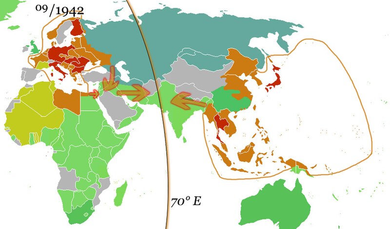
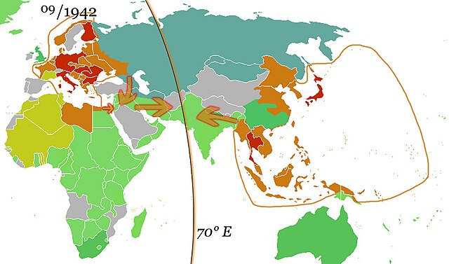
English: The German and the Japanese direct spheres of influence at their greatest extents during the Second World War in fall 1942. Arrows show planned movements to an agreed demarcation line at 70° E, which was, however, never even approximated.
The Allied countries.
Colonies, occupied territories and sphere of influence of the Allies.
The Axis countries.
Colonies, occupied territories and sphere of influence of the Axis
Vichy France and her remaining colonies.
The Soviet Union, its satellite states and sphere of influence.
Neutral countries. Deutsch: Die japanischen und deutschen direkten Einflusssphären während des zweiten Weltkrieges zum Zeitpunkt ihrer größten Ausdehnung im Herbst 1942. Pfeile zeigen geplante Bewegungen in Richtung einer vereinbarten Demarkationslinie entlang 70° östl. Länge, welche jedoch nie auch nur ansatzweise erreicht wurde.
Alliierte
Kolonien, besetzte Gebiete und Einflussbereiche der Alliierten
Achsenmächte
Kolonien, besetzte Gebiete und Einflussbereiche der Achse
Vichy-Frankreich und verbliebene Kolonien
Sowjetunion, ihre Satellitenstaaten und Einflussbereiche
Neutrale Staaten Русский: Немецкая и японская прямые сферы влияния достигли наибольшей степени во время Второй мировой войны осенью 1942 года. Стрелки показывают запланированные перемещения к согласованной демаркационной линии на 70° восточной долготы, которая, однако, никогда даже приблизительно не была определена.
Страны союзников.
Колонии, оккупированные территории и сферы влияния союзников.
Страны «Оси».
Колонии, оккупированные территории и сферы влияния стран Оси
Вишистская Франция и её оставшиеся колонии.
Советский Союз, его государства-сателлиты и сфера влияния.
Нейтральные страны. |
| Дата | (UTC) |
| Крыніца | |
| Аўтар |
|
| This is a retouched picture, which means that it has been digitally altered from its original version. Modifications: Added spheres of influence and 70° E.. The original can be viewed here: Ww2 allied axis.gif: File:Ww2 allied axis.gif. Modifications made by 36ophiuchi.
|
Я, уладальнік аўтарскіх правоў на гэты твор, добраахвотна публікую яго на ўмовах наступных ліцэнзій:
| Гэты файл даступны па ліцэнзіі Creative Commons Пазначэнне аўтарства - На тых самых умовах 3.0 Непартаваная | ||
| ||
| Гэтая картка дададзеная ў якасці часткі абнаўлення ліцэнзіі GFDL. |

|
Дазваляецца капіяваць, распаўсюджваць і(або) мадыфікаваць гэты дакумент на ўмовах ліцэнзіі GNU FDL версіі 1.2 або навейшай, выдадзенай Фондам свабоднага праграмнага забеспячэння; без Нязменных раздзелаў, без тэкстаў Вокладак. Копія ліцэнзіі ёсць у раздзеле GNU Free Documentation License. |
Вы можаце выбраць любую з гэтых ліцэнзій.
Журнал арыгінальнай загрузкі
This image is a derivative work of the following images:
- File:Ww2 allied axis.gif licensed with Cc-by-sa-3.0-migrated, GFDL
- 2010-04-07T22:14:13Z Hohum 1357x628 (106307 Bytes) Reverted to version as of 20:16, 25 November 2009 - problem is the wiki - not the image
- 2010-04-07T22:13:37Z Hohum 1357x628 (594030 Bytes) Reverted to version as of 17:47, 8 May 2009 - attempt to fix thumbnail
- 2009-11-25T20:16:27Z Bruce89 1357x628 (106307 Bytes) Optimised, some of it could be trimmed further
- 2009-05-08T17:47:59Z Rülpsmann 1357x628 (594030 Bytes) Reverted to version as of 08:29, 4 December 2006
- 2009-05-08T17:37:53Z Rülpsmann 1357x628 (594030 Bytes) less confusing, easier to understand if you think
- 2007-09-23T21:28:58Z Parhamr 1357x725 (272876 Bytes) this visual timeline communicates not only the dates but has some "visual context" of the time passed
- 2006-12-30T07:54:11Z Nxx 1357x628 (415308 Bytes) Reverted to earlier revision
- 2006-12-04T08:29:07Z Roke 1357x628 (594030 Bytes) use orange/green colours of original map
- 2006-05-19T04:36:35Z Roke 1357x628 (415308 Bytes) try version with sep 45 map, may not work as had problems
- 2006-05-18T20:04:37Z Roke 1357x628 (394879 Bytes) minor fix of some white lines in one frame
- 2006-05-18T19:38:30Z Roke 1357x628 (394934 Bytes) Western allies (blue), Soviet & allies (red) and Axis including Vichy French (black) during the [[w:Second World War|Second World War]]. Based on GNU image [[:Image:WWII.png]] [[Category:WWII maps (World)]] {{GFDL-self}}
Uploaded with derivativeFX
Гісторыя файла
Націснуць на даце з часам, каб паказаць файл, якім ён тады быў.
| Дата і час | Драбніца | Памеры | Удзельнік | Тлумачэнне | |
|---|---|---|---|---|---|
| актуальн. | 13:05, 15 кастрычніка 2010 | | 877 × 516 (172 KB) | 36ophiuchi~commonswiki | {{Information |Description={{en|The German and the Japanese direct spheres of influence at their greatest extents during the Second World War in fall 1942. Arrows show planned movements to an agreed demarcation line at 70° E, which was, however, never ev |
Выкарыстанне файла
Наступная 1 старонка выкарыстоўвае гэты файл:
Глабальнае выкарыстанне файла
Гэты файл выкарыстоўваецца ў наступных вікі:
- Выкарыстанне ў af.wikipedia.org
- Выкарыстанне ў ar.wikipedia.org
- Выкарыстанне ў arz.wikipedia.org
- Выкарыстанне ў ca.wikipedia.org
- Выкарыстанне ў de.wikipedia.org
- Выкарыстанне ў el.wikipedia.org
- Выкарыстанне ў en.wikipedia.org
- Выкарыстанне ў es.wikipedia.org
- Выкарыстанне ў fa.wikipedia.org
- Выкарыстанне ў fr.wikipedia.org
- Выкарыстанне ў hy.wikipedia.org
- Выкарыстанне ў id.wikipedia.org
- Выкарыстанне ў it.wikipedia.org
- Выкарыстанне ў ja.wikipedia.org
- Выкарыстанне ў kk.wikipedia.org
- Выкарыстанне ў ko.wikipedia.org
- Выкарыстанне ў lv.wikipedia.org
- Выкарыстанне ў mk.wikipedia.org
- Выкарыстанне ў nds.wikipedia.org
- Выкарыстанне ў nl.wikipedia.org
- Выкарыстанне ў ru.wikipedia.org
- Выкарыстанне ў uk.wikipedia.org
- Выкарыстанне ў uz.wikipedia.org
- Выкарыстанне ў www.wikidata.org
- Выкарыстанне ў zh.wikipedia.org