Файл:Great Lakes from space crop labeled.jpg
Няма версіі з большай раздзяляльнасцю.
Great_Lakes_from_space_crop_labeled.jpg (792 × 469 кропак, аб’ём файла: 96 KB, тып MIME: image/jpeg)
Тлумачэнне
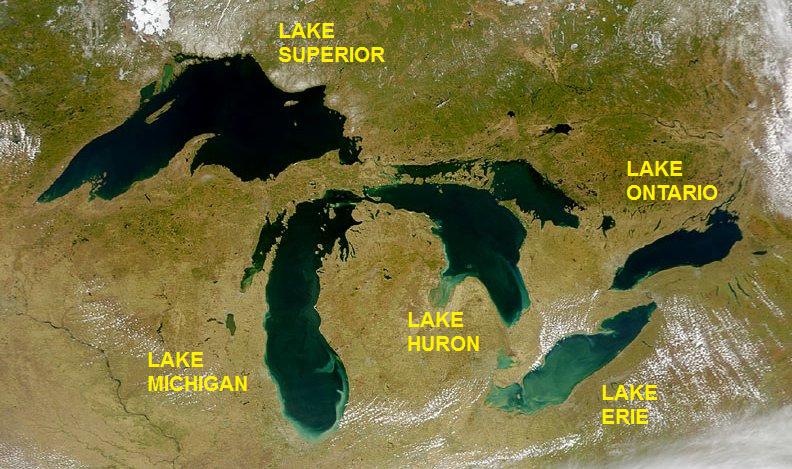
| Апісанне | Satellite image of the Great Lakes from space |
| Дата | |
| Крыніца | http://visibleearth.nasa.gov/view_rec.php?id=793 |
| Аўтар | SeaWiFS Project, NASA/Goddard Space Flight Center, and ORBIMAGE; cropped and labeled by Beyond My Ken (talk) 05:49, 11 September 2012 (UTC) |
| Іншыя версіі |
  |
Ліцэнзіяванне
| This image is from the Sea-viewing Wide Field-of-view Sensor (SeaWiFS) Project and more than 5 years old.
Satellite data captured by the SeaWIFS sensor are released into the public domain 5 years after capture. Data less than five years old can be re-used only for educational or scientific purposes; any commercial use of such images must be coordinated with GeoEye. [1] |
| This work has been released into the public domain by its copyright holder, GeoEye. This applies worldwide. У некаторых краінах гэта не можа быць юрыдычна магчыма; калі так, то: GeoEye дазваляе кожнаму выкарыстоўваць гэты твор ў любых мэтах, без аніякіх умоваў, калі толькі такія ўмовы не патрабуюцца паводле закону.
|
Гісторыя файла
Націснуць на даце з часам, каб паказаць файл, якім ён тады быў.
| Дата і час | Драбніца | Памеры | Удзельнік | Тлумачэнне | |
|---|---|---|---|---|---|
| актуальн. | 08:49, 11 верасня 2012 | | 792 × 469 (96 KB) | Beyond My Ken | == {{int:filedesc}} == {{Information |Description= Satellite image of the Great Lakes from space |Source= http://visibleearth.nasa.gov/view_rec.php?id=793 |Date= 2000-04-24 |Author= SeaWiFS Project, NASA/Goddard Space Flight Center, and ORBIMAGE; cropp... |
Выкарыстанне файла
Наступная 1 старонка выкарыстоўвае гэты файл:
Глабальнае выкарыстанне файла
Гэты файл выкарыстоўваецца ў наступных вікі:
- Выкарыстанне ў am.wikipedia.org
- Выкарыстанне ў as.wikipedia.org
- Выкарыстанне ў bh.wikipedia.org
- Выкарыстанне ў bn.wikipedia.org
- Выкарыстанне ў bs.wikipedia.org
- Выкарыстанне ў bxr.wikipedia.org
- Выкарыстанне ў ce.wikipedia.org
- Выкарыстанне ў ckb.wikipedia.org
- Выкарыстанне ў en.wikipedia.org
- Выкарыстанне ў en.wikibooks.org
- Выкарыстанне ў eo.wikipedia.org
- Выкарыстанне ў eu.wikipedia.org
- Выкарыстанне ў gl.wikipedia.org
- Выкарыстанне ў he.wikipedia.org
- Выкарыстанне ў he.wikivoyage.org
- Выкарыстанне ў hy.wikipedia.org
- Выкарыстанне ў ilo.wikipedia.org
- Выкарыстанне ў lfn.wikipedia.org
- Выкарыстанне ў mai.wikipedia.org
- Выкарыстанне ў ne.wikipedia.org
- Выкарыстанне ў new.wikipedia.org
- Выкарыстанне ў pa.wikipedia.org
- Выкарыстанне ў pt.wikipedia.org
- Выкарыстанне ў udm.wikipedia.org
- Выкарыстанне ў uz.wikipedia.org