Файл:Lake Titicaca Modis Sensor Nov 4 2001.jpg

Памер папярэдняга прагляду: 466 × 599 пікселяў. Іншыя разрозненні: 187 × 240 пікселяў | 373 × 480 пікселяў | 597 × 768 пікселяў | 796 × 1 024 пікселяў | 1 593 × 2 048 пікселяў | 2 800 × 3 600 пікселяў.
Арыгінальны файл (2 800 × 3 600 кропак, аб’ём файла: 2,06 MB, тып MIME: image/jpeg)
Тлумачэнне
| Апісанне |
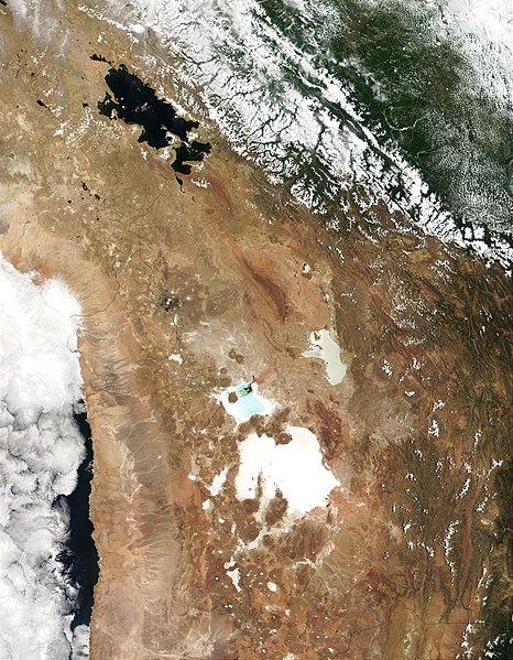
English: MODIS true-color image from November 4, 2001 showing the southern Altiplano including en:Lake Titicaca, the en:Salar de Uyuni, and the en:Salar de Coipasa. |
| Дата | |
| Крыніца |
http://visibleearth.nasa.gov/view_rec.php?id=2317
|
| Аўтар | Jacques Descloitres, MODIS Land Rapid Response Team, NASA/GSFC |
Ліцэнзіяванне
| This file is in the public domain in the United States because it was solely created by NASA. NASA copyright policy states that "NASA material is not protected by copyright unless noted". (See Template:PD-USGov, NASA copyright policy page or JPL Image Use Policy.) | ||
 |
Warnings:
|
Журнал арыгінальнай загрузкі
The original description page was here. All following user names refer to en.wikipedia.
- 2007-09-20 23:17 Nathancraig 2800×3600×8 (2159740 bytes) MODIS true-color image from November 4, 2001 showing the southern Altiplano including Lake Titicaca, the Salar de Atacama and the Salar de Coipasa.
Гісторыя файла
Націснуць на даце з часам, каб паказаць файл, якім ён тады быў.
| Дата і час | Драбніца | Памеры | Удзельнік | Тлумачэнне | |
|---|---|---|---|---|---|
| актуальн. | 21:13, 12 студзеня 2008 | | 2 800 × 3 600 (2,06 MB) | File Upload Bot (Magnus Manske) | {{BotMoveToCommons|en.wikipedia}} {{Information |Description={{en|MODIS true-color image from November 4, 2001 showing the southern Altiplano including en:Lake Titicaca, the en:Salar de Atacama, the en:Salar de Uyuni, and the [[:en:Salar d |
Выкарыстанне файла
Наступная 1 старонка выкарыстоўвае гэты файл:
Глабальнае выкарыстанне файла
Гэты файл выкарыстоўваецца ў наступных вікі:
- Выкарыстанне ў cs.wikipedia.org
- Выкарыстанне ў en.wikipedia.org
- Выкарыстанне ў es.wikipedia.org
- Выкарыстанне ў fr.wikipedia.org
- Выкарыстанне ў gl.wikipedia.org
- Выкарыстанне ў he.wikipedia.org
- Выкарыстанне ў hu.wikipedia.org
- Выкарыстанне ў it.wikipedia.org
- Выкарыстанне ў nn.wikipedia.org
- Выкарыстанне ў pt.wikipedia.org
- Выкарыстанне ў ru.wikipedia.org
- Выкарыстанне ў simple.wikipedia.org
- Выкарыстанне ў uk.wikipedia.org