Файл:London - John Norden's map of 1593.jpg

Арыгінальны файл (4 000 × 3 760 кропак, аб’ём файла: 4,01 MB, тып MIME: image/jpeg)
| Апісанне |
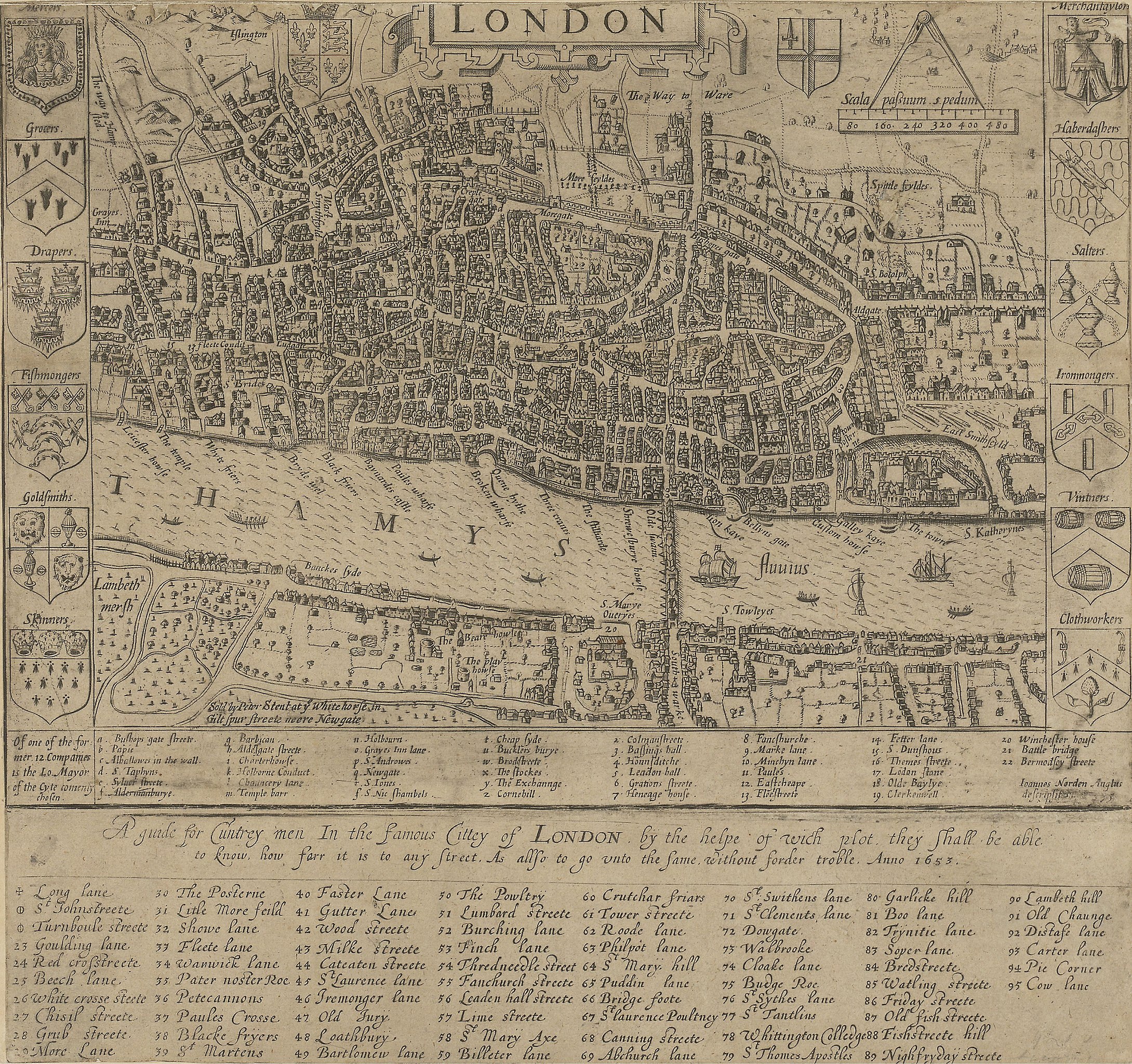
English: A guide for Cuntrey men In the famous Cittey of London. A map of London by John Norden, 1593. This copy comes from the 1653 edition of Norden's Speculum Britainiæ (Mirror of Britain), re-issued after his death.
There is only one bridge across the Thames, but parts of Southwark on the south bank of the river have been developed. The coats of arms around the edge belong to the twelve largest city guilds. These arms collectively were known as the "Great Liveries". Top right is the Merchant Tailors' arms.
|
||||
| Дата | 1593, re-issued in 1653 | ||||
| Крыніца | British Library: http://www.bl.uk/onlinegallery/onlineex/crace/a/007000000000001u00033000.html | ||||
| Аўтар | John Norden | ||||
| Дазвол (Паўторнае выкарыстанне гэтага файла) |
|
||||
Гісторыя файла
Націснуць на даце з часам, каб паказаць файл, якім ён тады быў.
| Дата і час | Драбніца | Памеры | Удзельнік | Тлумачэнне | |
|---|---|---|---|---|---|
| актуальн. | 05:49, 19 лютага 2010 | | 4 000 × 3 760 (4,01 MB) | Inductiveload | much higher res version |
| 13:54, 21 мая 2007 |  | 500 × 335 (43 KB) | Thomas Reid | {{Information |Description=John Norden's map of London in 1593. There is only one bridge across the Thames, but parts of en:Southwark on the south bank of the river have been developed. |Source=Originally from [http://en.wikipedia.org en.wikipedia]; |
Выкарыстанне файла
Наступная 1 старонка выкарыстоўвае гэты файл:
Глабальнае выкарыстанне файла
Гэты файл выкарыстоўваецца ў наступных вікі:
- Выкарыстанне ў ar.wikipedia.org
- Выкарыстанне ў be-tarask.wikipedia.org
- Выкарыстанне ў bg.wikipedia.org
- Выкарыстанне ў en.wikipedia.org
- Выкарыстанне ў en.wikibooks.org
- Выкарыстанне ў eo.wikipedia.org
- Выкарыстанне ў es.wikipedia.org
- Выкарыстанне ў fa.wikipedia.org
- Выкарыстанне ў ga.wikipedia.org
- Выкарыстанне ў he.wikipedia.org
- Выкарыстанне ў hr.wikipedia.org
- Выкарыстанне ў hu.wikipedia.org
- Выкарыстанне ў hy.wikipedia.org
- Выкарыстанне ў it.wikipedia.org
- Выкарыстанне ў ja.wikipedia.org
- Выкарыстанне ў kn.wikipedia.org
- Выкарыстанне ў ko.wikipedia.org
- Выкарыстанне ў my.wikipedia.org
- Выкарыстанне ў ro.wikipedia.org
- Выкарыстанне ў ru.wikipedia.org
- Выкарыстанне ў sco.wikipedia.org
- Выкарыстанне ў sh.wikipedia.org
- Выкарыстанне ў sl.wikipedia.org
- Выкарыстанне ў tum.wikipedia.org
- Выкарыстанне ў uk.wikipedia.org
- Выкарыстанне ў vi.wikipedia.org
- Выкарыстанне ў zh.wikipedia.org