Файл:Map of Land Ceded by Treaty of Fort Jackson.png
Няма версіі з большай раздзяляльнасцю.
Map_of_Land_Ceded_by_Treaty_of_Fort_Jackson.png (320 × 336 кропак, аб’ём файла: 25 KB, тып MIME: image/png)

|
This map image could be re-created using vector graphics as an SVG file. This has several advantages; see Commons:Media for cleanup for more information. If an SVG form of this image is available, please upload it and afterwards replace this template with
{{vector version available|new image name}}.
It is recommended to name the SVG file “Map of Land Ceded by Treaty of Fort Jackson.svg”—then the template Vector version available (or Vva) does not need the new image name parameter. |
Тлумачэнне
| Апісанне |
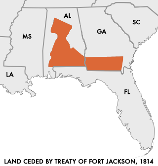
English: Map of Land Ceded to the United States by the warring Creek Nations in the Treaty of Fort Jackson of 1814.
User:Dystopos created this map using as reference a map "Creek Land Cessions Map 1733 through 1832" from the Horseshoe Bend National Military Park page on Areaparks.com [1] Polski: Mapa ziem scedowanych na rzecz USA przez Naród Krików na mocy Traktatu z Fort Jackson z 1814 roku |
| Дата | (upload to english Wikipedia) |
| Крыніца | http://en.wikipedia.org/wiki/Image:Map_of_Land_Ceded_by_Treaty_of_Fort_Jackson.png |
| Аўтар | User:Dystopos |
| Дазвол (Паўторнае выкарыстанне гэтага файла) |
No Rights Reserved |
Ліцэнзіяванне
| Гэты твор быў перададзены ў грамадскі набытак яго аутарам, Dystopos. Дазвол сапраўдны для ўсяго свету. У некаторых краінах гэта не можа быць юрыдычна магчыма; калі так, то: |
Гісторыя файла
Націснуць на даце з часам, каб паказаць файл, якім ён тады быў.
| Дата і час | Драбніца | Памеры | Удзельнік | Тлумачэнне | |
|---|---|---|---|---|---|
| актуальн. | 17:48, 28 сакавіка 2006 | | 320 × 336 (25 KB) | Cień | {{Information| |Description=Map of Land Ceded to the United States by the warring Creek Nations in the Treaty of Fort Jackson of 1814. I created this map using as reference a map "Creek Land Cessions Map 1733 through 1832" from the Horseshoe Bend |
Выкарыстанне файла
Наступная 1 старонка выкарыстоўвае гэты файл:
Глабальнае выкарыстанне файла
Гэты файл выкарыстоўваецца ў наступных вікі:
- Выкарыстанне ў ar.wikipedia.org
- Выкарыстанне ў ca.wikipedia.org
- Выкарыстанне ў da.wikipedia.org
- Выкарыстанне ў de.wikipedia.org
- Выкарыстанне ў en.wikipedia.org
- Выкарыстанне ў es.wikipedia.org
- Выкарыстанне ў fi.wikipedia.org
- Выкарыстанне ў fr.wikipedia.org
- Выкарыстанне ў it.wikipedia.org
- Выкарыстанне ў ja.wikipedia.org
- Выкарыстанне ў pl.wikipedia.org
- Выкарыстанне ў pt.wikipedia.org
- Выкарыстанне ў ro.wikipedia.org
- Выкарыстанне ў ru.wikipedia.org
- Выкарыстанне ў sr.wikipedia.org
- Выкарыстанне ў sv.wikipedia.org
- Выкарыстанне ў tr.wikipedia.org
- Выкарыстанне ў vi.wikipedia.org
- Выкарыстанне ў www.wikidata.org
- Выкарыстанне ў zh.wikipedia.org