Арыгінальны файл(1 174 × 1 200 кропак, аб’ём файла: 55 KB, тып MIME: image/png)

Гэты файл з на Вікісховішчы і можа выкарыстоўвацца іншымі праектамі. Апісанне на яго старонцы ў Wikimedia Commons прыведзена ніжэй.

Апісанне

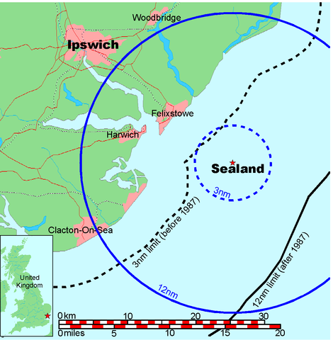
Map of Sealand

This is a map of the coast of England near Ipswich, showing the location of Sealand. The boundaries of the territorial water of the United Kingdom are also drawn, both the 3 nautical mile limit (5.556km) before 1987 and the 12nm limit (22.22km) after 1987. The same radii are also given around Sealand.

Note that these boundaries are derived based on the circular distance from the coastline, and not copied from official maps. This map is not suitable for navigation or for determining the boundaries of the UK territorial waters for legal or other purposes.

Стваральнік твора
Map generated by DEMIS World Map Server and edited by Chris 73
Дазвол
(Паўторнае выкарыстанне гэтага файла)


Licensing:

This image was created by Chris 73. The image is licensed under a dual license; please choose either of the two licenses below as desired. Attribution to Wikipedia or another project of the Wikimedia foundation is required for both licenses if the image is used outside of projects of the Wikimedia foundation. Attribution to me is not required.

GNU head Дазваляецца капіяваць, распаўсюджваць і/або змяняць гэты дакумент на ўмовах ліцэнзіі GNU FDL, Версіі 1.3 або навейшай, выдадзенай Фондам свабоднага праграмнага забеспячэння; без Нязменных раздзелаў, без Тэкстаў на пярэдняй вокладцы і без Тэкстаў на задняй вокладцы. Копія ліцэнзіі ёсць у раздзеле GNU Free Documentation License.

w:en:Creative Commons
атрыбуцыя распаўсюджванне на тых жа ўмовах
Пазначэнне аўтарства: Chris 73 / Wikimedia Commons
Вы можаце свабодна:
  • дзяліцца творам – капіраваць, распаўсюджваць і перадаваць гэты твор.
  • ствараць вытворныя творы – адаптаваць гэты твор
Пры выкананні наступных умоў:
  • атрыбуцыя – вы павінны пазначыць аўтарства гэтага твора, даць спасылку на ліцэнзію і пазначыць ці рабіў аўтар якія-небудзь змены. Гэта можна рабіць кожным зразумелым чынам, але не так, каб наводзіць па думку, што ліцэнзіят падтрымлівае вас або выкарыстанне вамі гэтага твора.
  • распаўсюджванне на тых жа ўмовах – Калі вы змяняеце, адаптуеце ці ствараеце вытворны твор на аснове гэтага, то павінны распаўсюджваць атрыманы ў выніку твор на ўмовах такой самай ці сумяшчальнай ліцэнзіі, што і арыгінал.

"I want to use the image. How do I do that?"

You can use this image freely for any purpose, including commercial use, provided that you license it under one of the above licenses. My suggestion is to use the following text:

This Wikipedia and Wikimedia Commons image is from the user Chris 73 and is freely available at //commons.wikimedia.org/wiki/File:Map_of_Sealand_with_territorial_waters.png under the creative commons cc-by-sa 3.0 license.

For privacy reasons please use only "Chris 73" as author. If necessary, please translate the text in your language. For electronic use please include the links in the text as shown, for printed use please print the text as shown. If you use the image I would appreciate it if you would let me know on my talk page, but this is not required as long as you follow one of the above licenses.


 Geotemporal data
Bounding box
N: 52.1374339°N
W: 0.9973602°E E: 1.6619722°E
S: 51.6274989°N
Georeferencing View the georeferenced map in the Wikimaps Warper

Назвы

Апішыце ў адным радку, што ўяўляе сабой гэты файл

Элементы, адлюстраваныя на гэтым файле

адлюстроўвае

image/png

checksum англійская

845a9e08cbe7ed93bae6eeabe454399a76e3324f

метад вызначэння: SHA-1 англійская

56 131 байт

1 200 піксель

1 174 піксель

Гісторыя файла

Націснуць на даце з часам, каб паказаць файл, якім ён тады быў.

Дата і часДрабніцаПамерыУдзельнікТлумачэнне
актуальн.22:41, 9 ліпеня 2006Драбніца версіі з 22:41, 9 ліпеня 20061 174 × 1 200 (55 KB)Chris 73update
13:00, 26 студзеня 2005Драбніца версіі з 13:00, 26 студзеня 20051 024 × 1 046 (50 KB)Chris 73

Наступная 1 старонка выкарыстоўвае гэты файл:

Глабальнае выкарыстанне файла

Гэты файл выкарыстоўваецца ў наступных вікі: