Файл:Mappa an Mor Keltek.png
Памер папярэдняга прагляду: 359 × 599 пікселяў. Іншыя разрозненні: 144 × 240 пікселяў | 431 × 719 пікселяў.
Арыгінальны файл (431 × 719 кропак, аб’ём файла: 24 KB, тып MIME: image/png)

|
This locator map image could be re-created using vector graphics as an SVG file. This has several advantages; see Commons:Media for cleanup for more information. If an SVG form of this image is available, please upload it and afterwards replace this template with
{{vector version available|new image name}}.
It is recommended to name the SVG file “Mappa an Mor Keltek.svg”—then the template Vector version available (or Vva) does not need the new image name parameter. |
Тлумачэнне
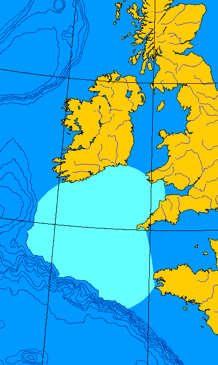
English: Map of the Celtic Sea. I made this file from a public domain original, generated at OMC.
Français : Carte de la Mer celtique. J'ai fait ce fichier-ci depuis une ébauche en domaine publique, générée à OMC. QuartierLatin1968 00:08, 15 Jun 2005 (UTC)
Ліцэнзіяванне
| Гэты твор быў перададзены ў грамадскі набытак яго аутарам, QuartierLatin1968. Дазвол сапраўдны для ўсяго свету. У некаторых краінах гэта не можа быць юрыдычна магчыма; калі так, то: |
Гісторыя файла
Націснуць на даце з часам, каб паказаць файл, якім ён тады быў.
| Дата і час | Драбніца | Памеры | Удзельнік | Тлумачэнне | |
|---|---|---|---|---|---|
| актуальн. | 03:08, 15 чэрвеня 2005 | | 431 × 719 (24 KB) | QuartierLatin1968 | {{PD-user}} *{{en}} Map of the Celtic Sea. I made this file from a public domain original, generated at [http://www.aquarius.geomar.de/omc/make_map.html OMC]. *{{fr}} Carte de la Mer celtique. J'ai fait ce fichier-ci depuis une ébauche en domaine publiqu |
Выкарыстанне файла
Наступная 1 старонка выкарыстоўвае гэты файл:
Глабальнае выкарыстанне файла
Гэты файл выкарыстоўваецца ў наступных вікі:
- Выкарыстанне ў an.wikipedia.org
- Выкарыстанне ў az.wikipedia.org
- Выкарыстанне ў bat-smg.wikipedia.org
- Выкарыстанне ў be-tarask.wikipedia.org
- Выкарыстанне ў bg.wikipedia.org
- Выкарыстанне ў bn.wikipedia.org
- Выкарыстанне ў ca.wikipedia.org
- Выкарыстанне ў ckb.wikipedia.org
- Выкарыстанне ў cy.wikipedia.org
- Выкарыстанне ў da.wikipedia.org
- Выкарыстанне ў de.wikipedia.org
- Выкарыстанне ў en.wikipedia.org
- Выкарыстанне ў eo.wikipedia.org
- Выкарыстанне ў es.wikipedia.org
- Выкарыстанне ў et.wikipedia.org
- Выкарыстанне ў fa.wikipedia.org
- Выкарыстанне ў fr.wikipedia.org
- Выкарыстанне ў fy.wikipedia.org
- Выкарыстанне ў gv.wikipedia.org
- Выкарыстанне ў he.wikipedia.org
- Выкарыстанне ў hu.wikipedia.org
- Выкарыстанне ў hy.wikipedia.org
- Выкарыстанне ў it.wikipedia.org
- Выкарыстанне ў ja.wikipedia.org
- Выкарыстанне ў ka.wikipedia.org
- Выкарыстанне ў kk.wikipedia.org
- Выкарыстанне ў ko.wikipedia.org
- Выкарыстанне ў ku.wikipedia.org
- Выкарыстанне ў kw.wikipedia.org
- Выкарыстанне ў la.wikipedia.org
- Выкарыстанне ў lmo.wikipedia.org
- Выкарыстанне ў lt.wikipedia.org
- Выкарыстанне ў mn.wikipedia.org
- Выкарыстанне ў nn.wikipedia.org
- Выкарыстанне ў no.wikipedia.org
- Выкарыстанне ў oc.wikipedia.org
- Выкарыстанне ў pl.wikipedia.org
- Выкарыстанне ў pnb.wikipedia.org
- Выкарыстанне ў pt.wikipedia.org
- Выкарыстанне ў ro.wikipedia.org
- Выкарыстанне ў ru.wikipedia.org
- Выкарыстанне ў simple.wikipedia.org
- Выкарыстанне ў sk.wikipedia.org
- Выкарыстанне ў vi.wikipedia.org
- Выкарыстанне ў war.wikipedia.org
- Выкарыстанне ў xmf.wikipedia.org