Файл:Routes of the Spanish Armada.gif

Памер папярэдняга прагляду: 329 × 599 пікселяў. Іншыя разрозненні: 132 × 240 пікселяў | 415 × 756 пікселяў.
Арыгінальны файл (415 × 756 кропак, аб’ём файла: 27 KB, тып MIME: image/gif)
Тлумачэнне
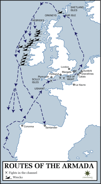
Map of the route taken by the Spanish Armada.
Source: History Department of the United States Military Academy at West Point
Other version: Classical Chinese translation, German translation, Spanish translation, French translation
.svg)
derivative works
Derivative works of this file: Routes of the Spanish Armada-es.svg
Ліцэнзіяванне
This work is in the public domain in the United States because it is a work prepared by an officer or employee of the United States Government as part of that person’s official duties under the terms of Title 17, Chapter 1, Section 105 of the US Code.
Note: This only applies to original works of the Federal Government and not to the work of any individual U.S. state, territory, commonwealth, county, municipality, or any other subdivision. This template also does not apply to postage stamp designs published by the United States Postal Service since 1978. (See § 313.6(C)(1) of Compendium of U.S. Copyright Office Practices). It also does not apply to certain US coins; see The US Mint Terms of Use.
|
 | |
| Гэты файл быў ідэнтыфікаваны як вольны ад вядомых абмежаванняў, згодна з законам аб аўтарскім праве, а таксама ад усіх сумежных правоў. | ||
Гісторыя файла
Націснуць на даце з часам, каб паказаць файл, якім ён тады быў.
| Дата і час | Драбніца | Памеры | Удзельнік | Тлумачэнне | |
|---|---|---|---|---|---|
| актуальн. | 17:23, 18 студзеня 2006 | | 415 × 756 (27 KB) | Kooma | ==Summary== Map of the route taken by the Spanish Armada. Source: [http://www.dean.usma.edu/history/atlases/dawn_modern_warfare/routes_armada.html History Department of the United States Military Academy at West Point] ==Licensing== {{PD-USGov}} [[ |
Выкарыстанне файла
Наступная 1 старонка выкарыстоўвае гэты файл:
Глабальнае выкарыстанне файла
Гэты файл выкарыстоўваецца ў наступных вікі:
- Выкарыстанне ў af.wikipedia.org
- Выкарыстанне ў azb.wikipedia.org
- Выкарыстанне ў az.wikipedia.org
- Выкарыстанне ў da.wikipedia.org
- Выкарыстанне ў da.wikibooks.org
- Выкарыстанне ў el.wikipedia.org
- Выкарыстанне ў en.wikipedia.org
- Выкарыстанне ў et.wikipedia.org
- Выкарыстанне ў fa.wikipedia.org
- Выкарыстанне ў fi.wikipedia.org
- Выкарыстанне ў fr.wikipedia.org
- Выкарыстанне ў ga.wikipedia.org
- Выкарыстанне ў hu.wikipedia.org
- Выкарыстанне ў hy.wikipedia.org
- Выкарыстанне ў it.wikipedia.org
- Выкарыстанне ў ja.wikipedia.org
- Выкарыстанне ў ka.wikipedia.org
- Выкарыстанне ў lv.wikipedia.org
- Выкарыстанне ў nl.wikipedia.org
- Выкарыстанне ў no.wikipedia.org
- Выкарыстанне ў pl.wikipedia.org
- Выкарыстанне ў pt.wikipedia.org
- Выкарыстанне ў ro.wikipedia.org
- Выкарыстанне ў simple.wikipedia.org
- Выкарыстанне ў sv.wikipedia.org
- Выкарыстанне ў ta.wikipedia.org
- Выкарыстанне ў uk.wikipedia.org
- Выкарыстанне ў www.wikidata.org