Файл:Turkey in Asia, 1903.jpg

Памер папярэдняга прагляду: 800 × 533 пікселяў. Іншыя разрозненні: 320 × 213 пікселяў | 640 × 427 пікселяў | 1 024 × 683 пікселяў | 1 280 × 853 пікселяў | 2 560 × 1 707 пікселяў | 6 000 × 4 000 пікселяў.
Арыгінальны файл (6 000 × 4 000 кропак, аб’ём файла: 4,67 MB, тып MIME: image/jpeg)
Тлумачэнне
| Апісанне |
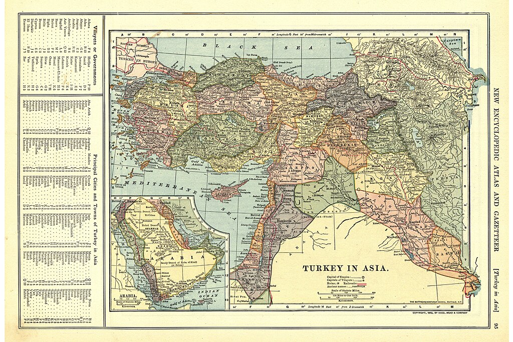
English: Turkey in Asia, 1909
|
| Дата | |
| Крыніца | University of Alabama Map Library |
| Аўтар | Patten, William and J.E. Homas |
| Іншыя версіі | Derivative works of this file: Arabian peninsula, 1909 (cropped).jpg |
.jpg)
.jpg)
Ліцэнзіяванне
This media file is in the public domain in the United States. This applies to U.S. works where the copyright has expired, often because its first publication occurred prior to January 1, 1929, and if not then due to lack of notice or renewal. See this page for further explanation.
|
 | |
 |
This image might not be in the public domain outside of the United States; this especially applies in the countries and areas that do not apply the rule of the shorter term for US works, such as Canada, Mainland China (not Hong Kong or Macao), Germany, Mexico, and Switzerland. The creator and year of publication are essential information and must be provided. See Wikipedia:Public domain and Wikipedia:Copyrights for more details.
|
Гісторыя файла
Націснуць на даце з часам, каб паказаць файл, якім ён тады быў.
| Дата і час | Драбніца | Памеры | Удзельнік | Тлумачэнне | |
|---|---|---|---|---|---|
| актуальн. | 13:57, 29 верасня 2011 | | 6 000 × 4 000 (4,67 MB) | Underlying lk |
Выкарыстанне файла
Наступныя 2 старонкі выкарыстоўваюць гэты файл:
Глабальнае выкарыстанне файла
Гэты файл выкарыстоўваецца ў наступных вікі:
- Выкарыстанне ў ar.wikipedia.org
- Выкарыстанне ў arz.wikipedia.org
- Выкарыстанне ў az.wikipedia.org
- Выкарыстанне ў ba.wikipedia.org
- Выкарыстанне ў de.wikipedia.org
- Выкарыстанне ў en.wikipedia.org
- Выкарыстанне ў eo.wikipedia.org
- Выкарыстанне ў id.wikipedia.org
- Выкарыстанне ў it.wikipedia.org
- Выкарыстанне ў ja.wikipedia.org
- Выкарыстанне ў ms.wikipedia.org
- Выкарыстанне ў pnb.wikipedia.org
- Выкарыстанне ў ro.wikipedia.org
- Выкарыстанне ў ru.wikipedia.org
- Выкарыстанне ў sr.wikipedia.org
- Выкарыстанне ў ur.wikipedia.org
- Выкарыстанне ў uz.wikipedia.org
- Выкарыстанне ў zh.wikipedia.org