Файл:Wake Island.png

Памер папярэдняга прагляду: 597 × 600 пікселяў. Іншыя разрозненні: 239 × 240 пікселяў | 631 × 634 пікселяў.
Арыгінальны файл (631 × 634 кропак, аб’ём файла: 307 KB, тып MIME: image/png)
|
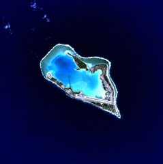
This is an image of a place or building that is listed on the National Register of Historic Places in the United States of America. Its reference number is 85002726. |
Wake Island - NASA NLT Landsat 7 (Visible Color) Satellite Image
| This file is in the public domain in the United States because it was solely created by NASA. NASA copyright policy states that "NASA material is not protected by copyright unless noted". (See Template:PD-USGov, NASA copyright policy page or JPL Image Use Policy.) | ||
 |
Warnings:
|
| Object location | | View this and other nearby images on: OpenStreetMap |
|---|
Гісторыя файла
Націснуць на даце з часам, каб паказаць файл, якім ён тады быў.
| Дата і час | Драбніца | Памеры | Удзельнік | Тлумачэнне | |
|---|---|---|---|---|---|
| актуальн. | 18:05, 10 красавіка 2005 | | 631 × 634 (307 KB) | Bollar | Wake Island - NASA NLT Landsat 7 (Visible Color) Satellite Image {{PD-USGov-NASA}} |
Выкарыстанне файла
Няма старонак, якія выкарыстоўваюць гэты файл.
Глабальнае выкарыстанне файла
Гэты файл выкарыстоўваецца ў наступных вікі:
- Выкарыстанне ў af.wikipedia.org
- Выкарыстанне ў als.wikipedia.org
- Выкарыстанне ў ast.wikipedia.org
- Выкарыстанне ў cr.wikipedia.org
- Выкарыстанне ў da.wikipedia.org
- Выкарыстанне ў de.wikipedia.org
- Выкарыстанне ў en.wikipedia.org
- Выкарыстанне ў es.wikipedia.org
- Выкарыстанне ў et.wikipedia.org
- Выкарыстанне ў eu.wikipedia.org
- Выкарыстанне ў fi.wikipedia.org
- Выкарыстанне ў frp.wikipedia.org
- Выкарыстанне ў frr.wikipedia.org
- Выкарыстанне ў fr.wikipedia.org
- Выкарыстанне ў gl.wikipedia.org
- Выкарыстанне ў hi.wikipedia.org
- Выкарыстанне ў id.wikipedia.org
- Выкарыстанне ў is.wikipedia.org
- Выкарыстанне ў it.wikipedia.org
- Выкарыстанне ў ja.wikinews.org
- Выкарыстанне ў jv.wikipedia.org
- Выкарыстанне ў ko.wikipedia.org
- Выкарыстанне ў la.wikipedia.org
- Выкарыстанне ў lv.wikipedia.org
- Выкарыстанне ў ms.wikipedia.org
- Выкарыстанне ў mt.wikipedia.org
- Выкарыстанне ў no.wikipedia.org
- Выкарыстанне ў pap.wikipedia.org
- Выкарыстанне ў pl.wiktionary.org
- Выкарыстанне ў pt.wikipedia.org
- Выкарыстанне ў ro.wikipedia.org
Паказаць глабальнае выкарыстанне гэтага файла.