Файл:Yugoslavia ethnic map.jpg
Памер папярэдняга прагляду: 574 × 599 пікселяў. Іншыя разрозненні: 230 × 240 пікселяў | 460 × 480 пікселяў | 736 × 768 пікселяў | 981 × 1 024 пікселяў | 1 643 × 1 715 пікселяў.
Арыгінальны файл (1 643 × 1 715 кропак, аб’ём файла: 837 KB, тып MIME: image/jpeg)

|
This ethnographic map image could be re-created using vector graphics as an SVG file. This has several advantages; see Commons:Media for cleanup for more information. If an SVG form of this image is available, please upload it and afterwards replace this template with
{{vector version available|new image name}}.
It is recommended to name the SVG file “Yugoslavia ethnic map.svg”—then the template Vector version available (or Vva) does not need the new image name parameter. |


Српски / srpski: jugoslawija
English: yugoslavia
Français : yougoslavie
Deutsch: jugoslawien
Тлумачэнне
| Апісанне |
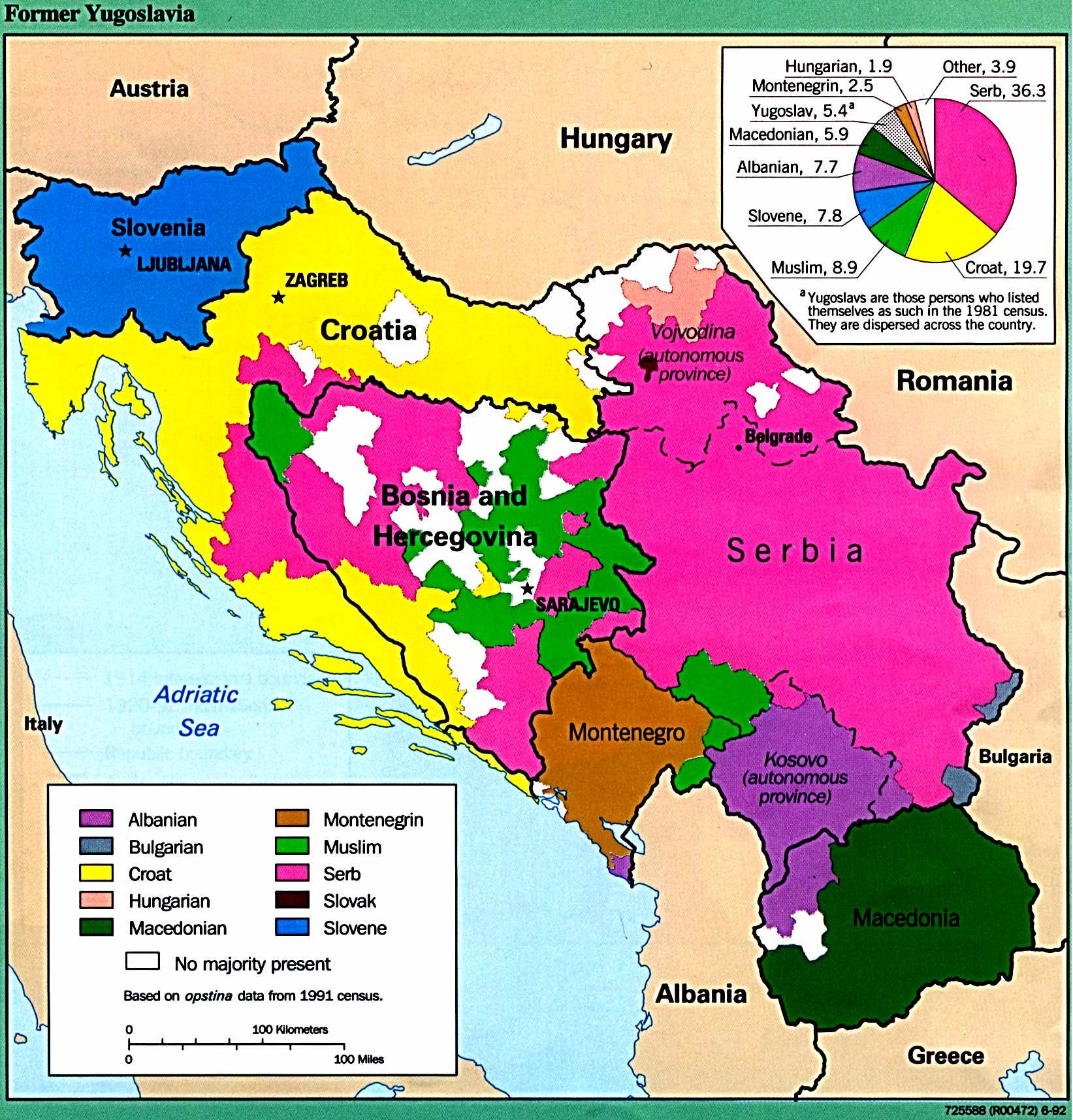
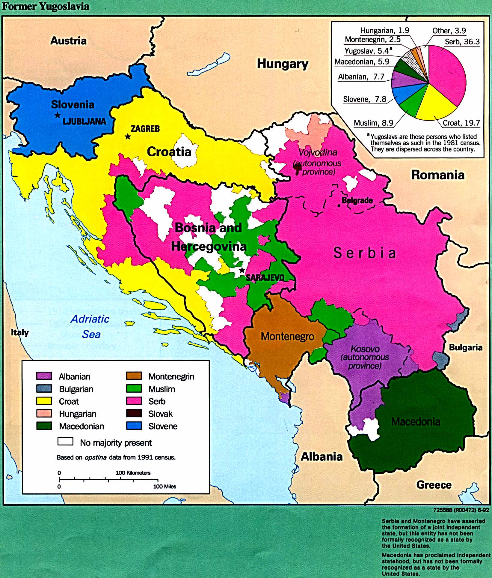
English: Ethnic map of Yugoslavia based on 1991 census data. |
| Дата | |
| Крыніца | http://www.lib.utexas.edu/maps/europe/yugoslav.jpg |
| Аўтар | The Former Yugoslavia: A Map Folio, published by the U.S. Central Intelligence Agency in 1992. |
| Дазвол (Паўторнае выкарыстанне гэтага файла) |
Most of the maps scanned by the University of Texas Libraries and served from this web site are in the public domain. No permissions are needed to copy them. You may download them and use them as you wish. A few maps are copyrighted, and are clearly marked as such. [1] |
Ліцэнзіяванне
This work is in the public domain in the United States because it is a work prepared by an officer or employee of the United States Government as part of that person’s official duties under the terms of Title 17, Chapter 1, Section 105 of the US Code.
Note: This only applies to original works of the Federal Government and not to the work of any individual U.S. state, territory, commonwealth, county, municipality, or any other subdivision. This template also does not apply to postage stamp designs published by the United States Postal Service since 1978. (See § 313.6(C)(1) of Compendium of U.S. Copyright Office Practices). It also does not apply to certain US coins; see The US Mint Terms of Use.
|
 | |
| Гэты файл быў ідэнтыфікаваны як вольны ад вядомых абмежаванняў, згодна з законам аб аўтарскім праве, а таксама ад усіх сумежных правоў. | ||
Гісторыя файла
Націснуць на даце з часам, каб паказаць файл, якім ён тады быў.
| Дата і час | Драбніца | Памеры | Удзельнік | Тлумачэнне | |
|---|---|---|---|---|---|
| актуальн. | 00:55, 8 ліпеня 2012 | | 1 643 × 1 715 (837 KB) | Kontrollstellekundl | old test deleted, + categories |
| 08:42, 23 снежня 2006 |  | 1 642 × 1 927 (403 KB) | El Cazangero | {{Information |Description=Yugoslav ethnic map according to census 1981 |Source=http://www.lib.utexas.edu/maps/europe/yugoslav.jpg |Date=12/23/2006 |Author=CIA |Permission= |other_versions= }} |
Выкарыстанне файла
Наступная 1 старонка выкарыстоўвае гэты файл:
Глабальнае выкарыстанне файла
Гэты файл выкарыстоўваецца ў наступных вікі:
- Выкарыстанне ў ar.wikipedia.org
- Выкарыстанне ў ast.wikipedia.org
- Выкарыстанне ў ca.wikipedia.org
- Выкарыстанне ў cs.wikipedia.org
- Выкарыстанне ў cy.wikipedia.org
- Выкарыстанне ў de.wikipedia.org
- Выкарыстанне ў el.wikipedia.org
- Выкарыстанне ў en.wikipedia.org
- Выкарыстанне ў es.wikipedia.org
- Выкарыстанне ў fi.wikipedia.org
- Выкарыстанне ў fr.wikipedia.org
- Выкарыстанне ў hr.wikipedia.org
- Выкарыстанне ў hu.wikipedia.org
- Выкарыстанне ў id.wikipedia.org
- Выкарыстанне ў it.wikipedia.org
- Выкарыстанне ў mk.wikipedia.org
- Выкарыстанне ў my.wikipedia.org
- Выкарыстанне ў nl.wikipedia.org
- Выкарыстанне ў pnb.wikipedia.org
- Выкарыстанне ў pt.wikipedia.org
- Выкарыстанне ў ro.wikipedia.org
- Выкарыстанне ў ru.wikipedia.org
- Выкарыстанне ў sh.wikipedia.org
- Выкарыстанне ў sl.wikipedia.org
- Выкарыстанне ў sr.wikibooks.org
- Выкарыстанне ў uk.wikipedia.org
- Выкарыстанне ў ur.wikipedia.org
- Выкарыстанне ў www.wikidata.org