Файл:Battle of Kruty.jpg

Памер папярэдняга прагляду: 800 × 529 пікселяў. Іншыя разрозненні: 320 × 212 пікселяў | 640 × 423 пікселяў | 1 003 × 663 пікселяў.
Арыгінальны файл (1 003 × 663 кропак, аб’ём файла: 82 KB, тып MIME: image/jpeg)
Тлумачэнне
| Апісанне |
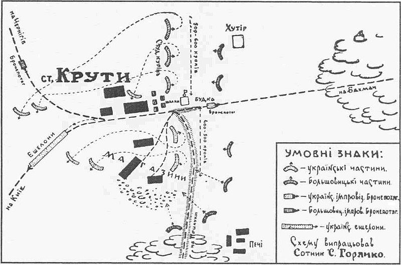
English: Map of the Battle of Kruty. Українська: Карта бою під крутами. |
|||
| Дата | ||||
| Крыніца | Ukrainian Wikipedia | |||
| Аўтар | Yevhen Malaniuk | |||
| Дазвол (Паўторнае выкарыстанне гэтага файла) |
|


|
This military map image could be re-created using vector graphics as an SVG file. This has several advantages; see Commons:Media for cleanup for more information. If an SVG form of this image is available, please upload it and afterwards replace this template with
{{vector version available|new image name}}.
It is recommended to name the SVG file “Battle of Kruty.svg”—then the template Vector version available (or Vva) does not need the new image name parameter. |


Гісторыя файла
Націснуць на даце з часам, каб паказаць файл, якім ён тады быў.
| Дата і час | Драбніца | Памеры | Удзельнік | Тлумачэнне | |
|---|---|---|---|---|---|
| актуальн. | 06:04, 17 лютага 2007 | | 1 003 × 663 (82 KB) | DDima | {{Information |Description={{en|Map of the Battle of Kruty.}} {{uk|Карта бою під крутами.}} |Source=[http://uk.wikipedia.org/wiki/Зображення:19yr.jpg Ukrainian Wikipedia] |Date=1941 |Author=Yevhen Malani |
Выкарыстанне файла
Наступная 1 старонка выкарыстоўвае гэты файл:
Глабальнае выкарыстанне файла
Гэты файл выкарыстоўваецца ў наступных вікі:
- Выкарыстанне ў be-tarask.wikipedia.org
- Выкарыстанне ў bg.wikipedia.org
- Выкарыстанне ў de.wikipedia.org
- Выкарыстанне ў en.wikipedia.org
- Выкарыстанне ў es.wikipedia.org
- Выкарыстанне ў et.wikipedia.org
- Выкарыстанне ў fr.wikipedia.org
- Выкарыстанне ў hy.wikipedia.org
- Выкарыстанне ў it.wikipedia.org
- Выкарыстанне ў lt.wikipedia.org
- Выкарыстанне ў pl.wikipedia.org
- Выкарыстанне ў ru.wikipedia.org
- Выкарыстанне ў uk.wikipedia.org
- 29 січня
- Бій під Крутами (1918)
- Вікіпедія:Цей день в історії/Січень
- Вікіпедія:Проєкт:Цей день в історії/29 січня
- Шаблон:Вибрані статті/Липень 2007
- Шаблон:Вибрана стаття/7 липня 2007
- Горячко Сергій Кузьмович
- Вікіпедія:Проєкт:Тематичний тиждень/Тиждень Чернігівщини 2020
- Список епізодів проєкту «Велич особистості»
- Выкарыстанне ў www.wikidata.org
- Выкарыстанне ў zh.wikipedia.org