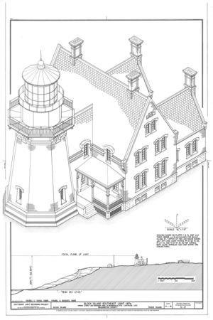
Файл:Block Island Southeast Light, Spring Street and Mohegan Trail at Mohegan Bluffs, New Shoreham, Washington County, RI HAER RI,5-NESH,1- (sheet 5 of 12).png

Арыгінальны файл(9 632 × 14 458 кропак, аб’ём файла: 6,34 MB, тып MIME: image/png)

Гэты файл з на Вікісховішчы і можа выкарыстоўвацца іншымі праектамі. Апісанне на яго старонцы ў Wikimedia Commons прыведзена ніжэй.

This image is a JPEG version of the original TIF image at File: Block Island Southeast Light, Spring Street and Mohegan Trail at Mohegan Bluffs, New Shoreham, Washington County, RI HAER RI,5-NESH,1- (sheet 5 of 12).tif.

However, any edits to the image should be based on the original TIF version in order to prevent generation loss, and both versions should be updated. Do not make edits based on this version.

Тлумачэнне

Warning The original file is very high-resolution. It might not load properly or could cause your browser to freeze when opened at full size.
HAER RI,5-NESH,1- (sheet 5 of 12) - Block Island Southeast Light, Spring Street and Mohegan Trail at Mohegan Bluffs, New Shoreham, Washington County, RI
Назва
HAER RI,5-NESH,1- (sheet 5 of 12) - Block Island Southeast Light, Spring Street and Mohegan Trail at Mohegan Bluffs, New Shoreham, Washington County, RI
Апісанне
Ball, Nicholas; Woodruff, I C; Tynan, T H; Paulding,Kemble and Company; Bailey and Debevoise
Depicted place Rhode Island; Washington County; New Shoreham
Дата Documentation compiled after 1968
Памеры 24 x 36 in. (D size)
Бягучае месцазнаходжанне
Library of Congress Prints and Photographs Division Washington, D.C. 20540 USA http://hdl.loc.gov/loc.pnp/pp.print
Асабісты нумар
HAER RI,5-NESH,1- (sheet 5 of 12)
Радок звестак аб набыцці
This file comes from the Historic American Buildings Survey (HABS), Historic American Engineering Record (HAER) or Historic American Landscapes Survey (HALS). These are programs of the National Park Service established for the purpose of documenting historic places. Records consist of measured drawings, archival photographs, and written reports.

This tag does not indicate the copyright status of the attached work. A normal copyright tag is still required. See Commons:Licensing.

Нататкі
  • Significance: The Block Island Southeast Lighthouse is significant as a primary aid to the navigation of an otherwise dangerous area, once referred to as the "stumbling block" of the New England coast. It marks the first island landfall for ships approaching New England from the south or southeast. It was the second light to be built on the island and the first on the south side. At the time of its completion in 1875 it was considered to be one of the finest and best equipped lighthouses on the east coast, featuring a first order Fresnel lens, the best in lighting apparatus technology. The lighthouse is also significant for its interesting design, a melding of Gothic Revival and Italianate styles taking form in an octagonal tower.
  • Unprocessed Field note material exists for this structure: FN-4
  • Survey number: HAER RI-27
  • Building/structure dates: 1875 Initial Construction
  • Building/structure dates: 1929 Subsequent Work
Крыніцы

This is an image of a place or building that is listed on the National Register of Historic Places in the United States of America. Its reference number is 97001264.

Крыніца https://www.loc.gov/pictures/item/ri0392.sheet.00005a
Дазвол
(Паўторнае выкарыстанне гэтага файла)
Public domain This image or media file contains material based on a work of a National Park Service employee, created as part of that person's official duties. As a work of the U.S. federal government, such work is in the public domain in the United States. See the NPS website and NPS copyright policy for more information.
Іншыя версіі
Object location41° 10′ 19,99″ N, 71° 33′ 29,99″ W Kartographer map based on OpenStreetMap.View this and other nearby images on: OpenStreetMapinfo

Назвы

Апішыце ў адным радку, што ўяўляе сабой гэты файл

Элементы, адлюстраваныя на гэтым файле

адлюстроўвае

coordinates of depicted place англійская

41°10'19.99"N, 71°33'29.99"W

image/png

checksum англійская

0888a24a904e0728d4f1c796c41eaace63a9ccf0

метад вызначэння: SHA-1 англійская

6 646 440 байт

14 458 піксель

9 632 піксель

Гісторыя файла

Націснуць на даце з часам, каб паказаць файл, якім ён тады быў.

Дата і часДрабніцаПамерыУдзельнікТлумачэнне
актуальн.03:38, 3 жніўня 2014Драбніца версіі з 03:38, 3 жніўня 20149 632 × 14 458 (6,34 MB){{Compressed version|file=File:Block_Island_Southeast_Light,_Spring_Street_and_Mohegan_Trail_at_Mohegan_Bluffs,_New_Shoreham,_Washington_County,_RI_HAER_RI,5-NESH,1-_(sheet_5_of_12).tif|thumb=nothumb}} =={{int:filedesc}}== {{Photograph | accession nu...

Наступная 1 старонка выкарыстоўвае гэты файл:

Глабальнае выкарыстанне файла

Гэты файл выкарыстоўваецца ў наступных вікі:

Метаданыя