Файл:Bog Asphodel - geograph.org.uk - 1402752.jpg
Bog_Asphodel_-_geograph.org.uk_-_1402752.jpg (640 × 480 кропак, аб’ём файла: 118 KB, тып MIME: image/jpeg)
Тлумачэнне
| Апісанне |
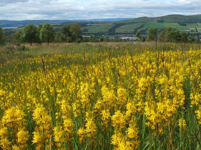
English: Bog Asphodel This is a closer view of some of the flowers that make up an extensive patch of Bog Asphodel (Narthecium ossifragum) on the grassy moors below Pappert Hill: 1402750.
This is a native species, found in bogs and other wet acidic habitats. After flowering, the dried-up remnants of the plant retain a strong orange-yellow colouring for quite some time. The specific name 'ossifragum' means 'bone-breaker'; as is explained in Richard Mabey's "Flora Britannica", that name is indirectly related to the habitat in which the plant is found: "it derives from the belief that grazing the plant made the bones of sheep brittle – though it was not bog asphodel which caused this, but the sour calcium-poor pastures in which it occurs". As for the background, a small part of the River Clyde can be seen at the far left. Slightly to the left of centre, visible as little more than a thin pale-blue line near the top of a hill, is Carman Reservoir. The hills to the right of centre are Carman Hill and Overton Muir. |
| Дата | |
| Крыніца | From geograph.org.uk |
| Аўтар | Lairich Rig |
| Пазначэнне аўтарства (required by the license) | Lairich Rig / Bog Asphodel / |
| Camera location | | View this and other nearby images on: OpenStreetMap |
|---|
_heading:247.00&language=be)
| Object location | | View this and other nearby images on: OpenStreetMap |
|---|
_heading:247.00&language=be)
Ліцэнзіяванне

|
This image was taken from the Geograph project collection. See this photograph's page on the Geograph website for the photographer's contact details. The copyright on this image is owned by Lairich Rig and is licensed for reuse under the Creative Commons Attribution-ShareAlike 2.0 license.
|
- Вы можаце свабодна:
- дзяліцца творам – капіраваць, распаўсюджваць і перадаваць гэты твор.
- ствараць вытворныя творы – адаптаваць гэты твор
- Пры выкананні наступных умоў:
- атрыбуцыя – вы павінны пазначыць аўтарства гэтага твора, даць спасылку на ліцэнзію і пазначыць ці рабіў аўтар якія-небудзь змены. Гэта можна рабіць кожным зразумелым чынам, але не так, каб наводзіць па думку, што ліцэнзіят падтрымлівае вас або выкарыстанне вамі гэтага твора.
- распаўсюджванне на тых жа ўмовах – Калі вы змяняеце, адаптуеце ці ствараеце вытворны твор на аснове гэтага, то павінны распаўсюджваць атрыманы ў выніку твор на ўмовах такой самай ці сумяшчальнай ліцэнзіі, што і арыгінал.
Гісторыя файла
Націснуць на даце з часам, каб паказаць файл, якім ён тады быў.
| Дата і час | Драбніца | Памеры | Удзельнік | Тлумачэнне | |
|---|---|---|---|---|---|
| актуальн. | 14:49, 1 сакавіка 2011 | | 640 × 480 (118 KB) | GeographBot | == {{int:filedesc}} == {{Information |description={{en|1=Bog Asphodel This is a closer view of some of the flowers that make up an extensive patch of Bog Asphodel (Narthecium ossifragum) on the grassy moors below Pappert Hill: 1402750. This is a na |
Выкарыстанне файла
Наступная 1 старонка выкарыстоўвае гэты файл:
Глабальнае выкарыстанне файла
Гэты файл выкарыстоўваецца ў наступных вікі:
- Выкарыстанне ў cs.wikipedia.org
- Выкарыстанне ў en.wikipedia.org
- Выкарыстанне ў fr.wikivoyage.org
- Выкарыстанне ў id.wikipedia.org
- Выкарыстанне ў it.wikipedia.org
- Выкарыстанне ў nn.wikipedia.org
- Выкарыстанне ў uk.wikipedia.org
- Выкарыстанне ў vi.wikipedia.org