Файл:Boucle GOES8-1998-01 07-09.gif
Няма версіі з большай раздзяляльнасцю.
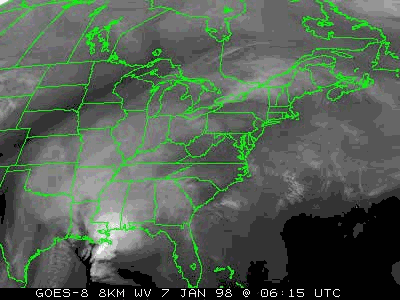
Boucle_GOES8-1998-01_07-09.gif (400 × 300 кропак, аб’ём файла: 1,01 MB, тып MIME: image/gif, закальцаваныя, 22 кадраў, 7,6 s)
Тлумачэнне
| Апісанне |
English: Loop of water vapor image from GOES-8 weather satellite for the period of January 7th to 9th 1998. This picture shows the weather systems evolution during part of the North American ice storm of 1998.
Français : Photo du satellite météorologique GOES-8 dans le spectre de détection de la vapeur d'eau. Cette image montre l'évolution des nuages du 7 au 9 janvier 1998, soit une partie du Verglas massif de 1998. |
| Дата | |
| Крыніца | http://www.ncdc.noaa.gov/oa/reports/janstorm/janstorm.html |
| Аўтар | National Climatic Data Center of United States National Weather Service |
This picture is an animated GIF version of the MPEG original.
Cette boucle est une version GIF animée de l'originale en MPEG.
Ліцэнзіяванне
This image is in the public domain because it contains materials that originally came from the U.S. National Oceanic and Atmospheric Administration, taken or made as part of an employee's official duties.
|
Гісторыя файла
Націснуць на даце з часам, каб паказаць файл, якім ён тады быў.
| Дата і час | Драбніца | Памеры | Удзельнік | Тлумачэнне | |
|---|---|---|---|---|---|
| актуальн. | 14:41, 12 чэрвеня 2009 | | 400 × 300 (1,01 MB) | Pierre cb | {{Information |Description={{en|1=Loop of water vapor image from GOES-8 weather satellite for the period of January 7th to 9th 1998. This picture shows the weather systems evolution during part of the [[:enNorth American ice storm of 1998|North American i |
Выкарыстанне файла
Наступная 1 старонка выкарыстоўвае гэты файл:
Глабальнае выкарыстанне файла
Гэты файл выкарыстоўваецца ў наступных вікі:
- Выкарыстанне ў fr.wikipedia.org
- Verglas massif de janvier 1998 dans le Nord-Est de l'Amérique du Nord
- Portail:Météorologie/12
- Wikipédia:Sélection/Québec
- Wikipédia:Lumière sur/Juillet 2010
- Wikipédia:Lumière sur/Verglas massif de janvier 1998 dans le Nord-Est de l'Amérique du Nord
- Wikipédia:Sélection/Histoire du Québec
- Wikipédia:Sélection/États-Unis/Bons articles/Partie III
- Выкарыстанне ў si.wikipedia.org
- Выкарыстанне ў sr.wikipedia.org