Файл:Ice-floe params hg.png

Памер папярэдняга прагляду: 800 × 392 пікселяў. Іншыя разрозненні: 320 × 157 пікселяў | 640 × 314 пікселяў | 1 024 × 502 пікселяў | 1 280 × 628 пікселяў | 2 800 × 1 373 пікселяў.
Арыгінальны файл (2 800 × 1 373 кропак, аб’ём файла: 115 KB, тып MIME: image/png)
| Апісанне |
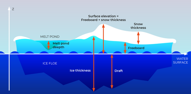
English: Section through an ice floe with parameters used in glaciological research to quantify and describe the coverage of sea ice
Русский: Сечение льдины и её параетры, используемые в гляциологии для описания и количественных оценок покрытия морей льдом.
|
| Дата | |
| Крыніца | own work, redrawn from a draft by Valerij Cysko under the supervision of Dr. Christian Haas, geophysicist at Alfred Wegener Institute for Polar and Marine Research, Bremerhaven |
| Аўтар | Amanda Grobe & Hannes Grobe 21:53, 12 August 2006 (UTC), Alfred Wegener Institute for Polar and Marine Research, Bremerhaven, Germany |
| Дазвол (Паўторнае выкарыстанне гэтага файла) |
own work, share alike, attribution required (Creative Commons CC-BY-SA-2.5) |
| Іншыя версіі | original grafic in Intaglio format available from the author |
Я, уладальнік аўтарскіх правоў на гэты твор, добраахвотна публікую яго на ўмовах наступнай ліцэнзіі:
Гэты файл даступны па ліцэнзіі Creative Commons Пазначэнне аўтарства - На тых самых умовах 2.5 Агульны
- Вы можаце свабодна:
- дзяліцца творам – капіраваць, распаўсюджваць і перадаваць гэты твор.
- ствараць вытворныя творы – адаптаваць гэты твор
- Пры выкананні наступных умоў:
- атрыбуцыя – вы павінны пазначыць аўтарства гэтага твора, даць спасылку на ліцэнзію і пазначыць ці рабіў аўтар якія-небудзь змены. Гэта можна рабіць кожным зразумелым чынам, але не так, каб наводзіць па думку, што ліцэнзіят падтрымлівае вас або выкарыстанне вамі гэтага твора.
- распаўсюджванне на тых жа ўмовах – Калі вы змяняеце, адаптуеце ці ствараеце вытворны твор на аснове гэтага, то павінны распаўсюджваць атрыманы ў выніку твор на ўмовах такой самай ці сумяшчальнай ліцэнзіі, што і арыгінал.

|
This geology image could be re-created using vector graphics as an SVG file. This has several advantages; see Commons:Media for cleanup for more information. If an SVG form of this image is available, please upload it and afterwards replace this template with
{{vector version available|new image name}}.
It is recommended to name the SVG file “Ice-floe params hg.svg”—then the template Vector version available (or Vva) does not need the new image name parameter. |
Гісторыя файла
Націснуць на даце з часам, каб паказаць файл, якім ён тады быў.
| Дата і час | Драбніца | Памеры | Удзельнік | Тлумачэнне | |
|---|---|---|---|---|---|
| актуальн. | 00:29, 25 верасня 2023 | | 2 800 × 1 373 (115 KB) | Beao | Cropped 13 % vertically using CropTool with lossless mode. Removed watermark. |
| 02:10, 21 красавіка 2022 |  | 2 800 × 1 576 (130 KB) | RASPBERRY VIBE | Image resolution increase, data structuring. | |
| 07:42, 21 жніўня 2006 |  | 675 × 376 (157 KB) | Hgrobe | {{Information| |Description=Section through an ice floe with parameters used in glaciological research to quantify and describe the coverage of sea ice * '''Ice thickness''': total thickness of the ice floe (draft + freeboard) * '''Freeboard''': part of t | |
| 07:34, 21 жніўня 2006 |  | 783 × 559 (163 KB) | Hgrobe | {{Information| |Description=Section through an ice floe with parameters used in glaciological research to quantify and describe the coverage of sea ice * '''Ice thickness''': total thickness of the ice floe (draft + freeboard) * '''Freeboard''': part of t | |
| 00:53, 13 жніўня 2006 |  | 1 006 × 557 (261 KB) | Hgrobe | {{Information| |Description=Section through an ice floe with parameters used in glaciological research to quantify and describe the coverage of sea ice |Source=own work |Date=2006-08-08 |Author=~~~~ |Permission=Own work, share alike, attribution required |
Выкарыстанне файла
Наступная 1 старонка выкарыстоўвае гэты файл:
Глабальнае выкарыстанне файла
Гэты файл выкарыстоўваецца ў наступных вікі:
- Выкарыстанне ў bn.wikipedia.org
- Выкарыстанне ў ca.wikipedia.org
- Выкарыстанне ў cv.wikipedia.org
- Выкарыстанне ў de.wikipedia.org
- Выкарыстанне ў el.wikipedia.org
- Выкарыстанне ў en.wikipedia.org
- Выкарыстанне ў en.wiktionary.org
- Выкарыстанне ў es.wikipedia.org
- Выкарыстанне ў it.wikipedia.org
- Выкарыстанне ў ja.wikipedia.org
- Выкарыстанне ў ko.wikipedia.org
- Выкарыстанне ў mnw.wiktionary.org
- Выкарыстанне ў nl.wikipedia.org
- Выкарыстанне ў nn.wikipedia.org
- Выкарыстанне ў no.wikipedia.org
- Выкарыстанне ў simple.wikipedia.org
- Выкарыстанне ў uk.wikipedia.org
- Выкарыстанне ў zh.wikipedia.org
- Выкарыстанне ў zh.wiktionary.org