Файл:Leonhard Euler World Map AD1760.jpg

Памер папярэдняга прагляду: 696 × 599 пікселяў. Іншыя разрозненні: 279 × 240 пікселяў | 557 × 480 пікселяў | 892 × 768 пікселяў | 1 189 × 1 024 пікселяў | 2 378 × 2 048 пікселяў | 2 615 × 2 252 пікселяў.
Арыгінальны файл (2 615 × 2 252 кропак, аб’ём файла: 2,79 MB, тып MIME: image/jpeg)
Тлумачэнне
| Апісанне |
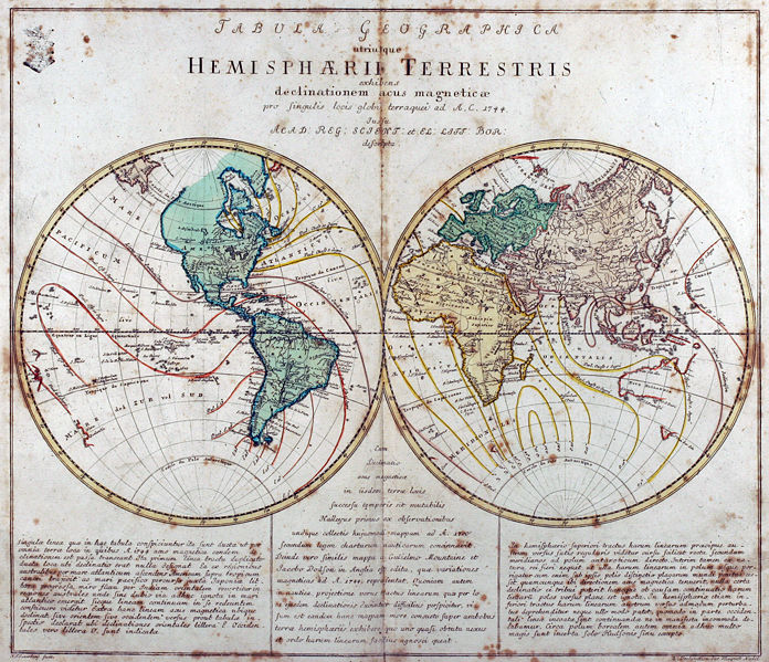
Tabula Geographica utriusque Hemisphaerii Terrestris exhibens declinationem acus magneticae pro singulis locis globi terraquei ad A. C. 1744. Iussu Acad: Reg: Scient: et El: Litt: Bor: descripta. Deutsch: Kupferstich-Weltkarte von Leonhard Euler aus seinem Schulatlas Geographischer Atlas bestehend in 44 Land-Charten erstmals 1753 in Berlin erschienen
English: Engraved world map (including magnetic declination lines) by Leonhard Euler from his school atlas “Geographischer Atlas bestehend in 44 Land-Charten” first published 1753 in Berlin |
||||||||||||||||||||||||||
| Дата | |||||||||||||||||||||||||||
| Крыніца | Antique-World: Antique World Map by Leonhard Euler | ||||||||||||||||||||||||||
| Аўтар |
|
||||||||||||||||||||||||||
| Дазвол (Паўторнае выкарыстанне гэтага файла) |
Own work | ||||||||||||||||||||||||||

Ліцэнзіяванне
|
This work is in the public domain in its country of origin and other countries and areas where the copyright term is the author's life plus 100 years or fewer. This work is in the public domain in the United States because it was published (or registered with the U.S. Copyright Office) before January 1, 1929. | |
| Гэты файл быў ідэнтыфікаваны як вольны ад вядомых абмежаванняў, згодна з законам аб аўтарскім праве, а таксама ад усіх сумежных правоў. | |
Гісторыя файла
Націснуць на даце з часам, каб паказаць файл, якім ён тады быў.
| Дата і час | Драбніца | Памеры | Удзельнік | Тлумачэнне | |
|---|---|---|---|---|---|
| актуальн. | 05:08, 26 красавіка 2008 | | 2 615 × 2 252 (2,79 MB) | Ray007 | == Summary == {{Information |Description={{de|Kupferstich Weltkarte von Leonahrd Euler aus seinem Schulatlas "Geographischer Atlas bestehend in 44 Land-Charten" erstmals 1753 in Berlin erschienen}} {{en|Engraved world map by Leonahrd Euler from his school |
| 04:39, 26 красавіка 2008 |  | 3 504 × 2 336 (4,88 MB) | Ray007 | {{Information |Description={{de|Kupferstich Weltkarte von Leonahrd Euler aus seinem Schulatlas "Geographischer Atlas bestehend in 44 Land-Charten" erstmals 1753 in Berlin erschienen}} {{en|Engraved world map by Leonahrd Euler from his school atlas "Geogra |
Выкарыстанне файла
Наступная 1 старонка выкарыстоўвае гэты файл:
Глабальнае выкарыстанне файла
Гэты файл выкарыстоўваецца ў наступных вікі:
- Выкарыстанне ў ar.wikipedia.org
- Выкарыстанне ў ast.wikipedia.org
- Выкарыстанне ў br.wikipedia.org
- Выкарыстанне ў de.wikipedia.org
- Выкарыстанне ў en.wikipedia.org
- Выкарыстанне ў eo.wikiquote.org
- Выкарыстанне ў eu.wikipedia.org
- Выкарыстанне ў fr.wikipedia.org
- Выкарыстанне ў ia.wikipedia.org
- Выкарыстанне ў ko.wikipedia.org
- Выкарыстанне ў ru.wikipedia.org
- Выкарыстанне ў sh.wikipedia.org
- Выкарыстанне ў sr.wikipedia.org
- Выкарыстанне ў tr.wikipedia.org
- Выкарыстанне ў www.wikidata.org