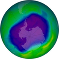
Файл:NASA and NOAA Announce Ozone Hole is a Double Record Breaker.png

Памер папярэдняга прагляду: 600 × 600 пікселяў. Іншыя разрозненні: 240 × 240 пікселяў | 480 × 480 пікселяў | 716 × 716 пікселяў.
Арыгінальны файл (716 × 716 кропак, аб’ём файла: 411 KB, тып MIME: image/png)
Гісторыя файла
Націснуць на даце з часам, каб паказаць файл, якім ён тады быў.
| Дата і час | Драбніца | Памеры | Удзельнік | Тлумачэнне | |
|---|---|---|---|---|---|
| актуальн. | 05:40, 18 лютага 2012 |  | 716 × 716 (411 KB) | Ras67 | JPEG artifacts mitigated and background removed |
| 23:29, 28 жніўня 2007 |  | 716 × 716 (409 KB) | Nils Simon |
Выкарыстанне файла
Наступная 1 старонка выкарыстоўвае гэты файл:
Глабальнае выкарыстанне файла
Гэты файл выкарыстоўваецца ў наступных вікі:
- Выкарыстанне ў af.wikipedia.org
- Выкарыстанне ў als.wikipedia.org
- Выкарыстанне ў ar.wikipedia.org
- Выкарыстанне ў az.wikipedia.org
- Выкарыстанне ў bg.wikipedia.org
- Выкарыстанне ў bn.wikipedia.org
- Выкарыстанне ў bs.wikipedia.org
- Выкарыстанне ў ca.wikipedia.org
- Выкарыстанне ў cs.wikipedia.org
- Выкарыстанне ў cv.wikipedia.org
- Выкарыстанне ў de.wikipedia.org
- Выкарыстанне ў de.wikibooks.org
- Выкарыстанне ў el.wikipedia.org
- Выкарыстанне ў en.wikipedia.org
- Выкарыстанне ў en.wikibooks.org
- Выкарыстанне ў en.wikinews.org
- Выкарыстанне ў es.wikipedia.org
Паказаць глабальнае выкарыстанне гэтага файла.

