Файл:The Diomede Islands in the BeringSea (picture from space).jpg
Памер папярэдняга прагляду: 750 × 600 пікселяў. Іншыя разрозненні: 300 × 240 пікселяў | 600 × 480 пікселяў | 900 × 720 пікселяў.
Арыгінальны файл (900 × 720 кропак, аб’ём файла: 66 KB, тып MIME: image/jpeg)
.jpg)
Тлумачэнне
| Апісанне |
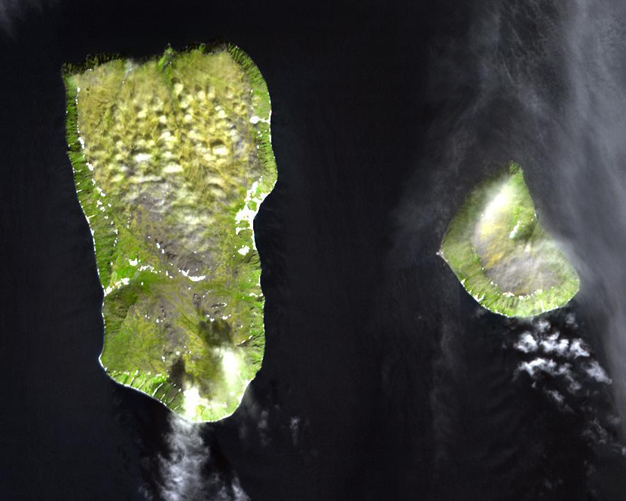
English: Diomede Islands in the middle of the Bering Strait:. The islands are separated by the border between Russia and the USA and by the International Date Line.
|
| Дата | |
| Крыніца |
|
| Аўтар | Невядомы |
| Дазвол (Паўторнае выкарыстанне гэтага файла) |
This file is in the public domain because it was created by NASA. NASA copyright policy states that "NASA material is not protected by copyright unless noted". (NASA copyright policy page or JPL Image Use Policy). This image does not contain a NASA logo. |
Ліцэнзіяванне
| This file is in the public domain in the United States because it was solely created by NASA. NASA copyright policy states that "NASA material is not protected by copyright unless noted". (See Template:PD-USGov, NASA copyright policy page or JPL Image Use Policy.) | ||
 |
Warnings:
|
Гісторыя файла
Націснуць на даце з часам, каб паказаць файл, якім ён тады быў.
| Дата і час | Драбніца | Памеры | Удзельнік | Тлумачэнне | |
|---|---|---|---|---|---|
| актуальн. | 08:25, 11 жніўня 2008 | | 900 × 720 (66 KB) | Micov | {{Information |Description={{en|1=The boarder between the USSR and the USA in the cold war. }} |Source=This file is in the public domain because it was created by NASA. NASA copyright policy stat |
Выкарыстанне файла
Наступная 1 старонка выкарыстоўвае гэты файл:
Глабальнае выкарыстанне файла
Гэты файл выкарыстоўваецца ў наступных вікі:
- Выкарыстанне ў af.wikipedia.org
- Выкарыстанне ў ar.wikipedia.org
- Выкарыстанне ў ast.wikipedia.org
- Выкарыстанне ў az.wikipedia.org
- Выкарыстанне ў ca.wikipedia.org
- Выкарыстанне ў da.wikipedia.org
- Выкарыстанне ў de.wikipedia.org
- Выкарыстанне ў en.wikipedia.org
- Выкарыстанне ў es.wikipedia.org
- Выкарыстанне ў fi.wikipedia.org
- Выкарыстанне ў fr.wikipedia.org
- Выкарыстанне ў fr.wiktionary.org
- Выкарыстанне ў he.wikipedia.org
- Выкарыстанне ў hy.wikipedia.org
- Выкарыстанне ў id.wikipedia.org
- Выкарыстанне ў it.wikipedia.org
- Выкарыстанне ў ja.wikipedia.org
- Выкарыстанне ў mk.wikipedia.org
- Выкарыстанне ў nl.wikipedia.org
- Выкарыстанне ў pl.wikipedia.org
- Выкарыстанне ў ru.wikipedia.org
- Выкарыстанне ў simple.wikipedia.org
- Выкарыстанне ў sv.wikipedia.org
- Выкарыстанне ў tr.wikipedia.org
- Выкарыстанне ў vi.wikipedia.org
- Выкарыстанне ў www.wikidata.org
- Выкарыстанне ў zh.wikipedia.org
.jpg)