Файл:USACE Black Butte Dam and Lake.jpg

Памер папярэдняга прагляду: 800 × 526 пікселяў. Іншыя разрозненні: 320 × 211 пікселяў | 640 × 421 пікселяў | 1 024 × 674 пікселяў | 1 500 × 987 пікселяў.
Арыгінальны файл (1 500 × 987 кропак, аб’ём файла: 619 KB, тып MIME: image/jpeg)
| Апісанне |
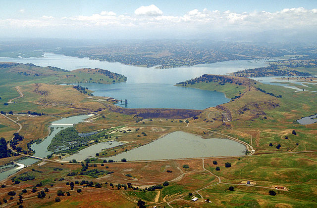
English: Aerial view of Black Butte Dam and Lake in Tehama County, California, USA. The dam was constructed in 1963 for flood control on Stony Creek. The dam is located approximately 9 miles (14.5 km) west of Orland, California.
Coordinates: 39°49′1.17″N 122°20′14.13″W / 39.8169917°N 122.3372583°W |
|||
| Location | Tehama and Glenn Counties, California, USA | |||
| Дата | not specified or unknown | |||
| Крыніца |
U.S. Army Corps of Engineers Digital Visual Library Image page Image description page Digital Visual Library home page |
|||
| Аўтар | Michael Nevins, U.S. Army Corps of Engineers | |||
| Дазвол (Паўторнае выкарыстанне гэтага файла) |
|
Гісторыя файла
Націснуць на даце з часам, каб паказаць файл, якім ён тады быў.
| Дата і час | Драбніца | Памеры | Удзельнік | Тлумачэнне | |
|---|---|---|---|---|---|
| актуальн. | 08:47, 5 мая 2007 | | 1 500 × 987 (619 KB) | DanMS | {{Information | Description = {{en|Aerial view of Black Butte Dam and Lake in Tehama County, California, USA. The dam was constructed in 1963 for flood control on Stony Creek. The dam is located approximately 9 miles (15.4 km) west of Orland, Californi |
Выкарыстанне файла
Наступная 1 старонка выкарыстоўвае гэты файл:
Глабальнае выкарыстанне файла
Гэты файл выкарыстоўваецца ў наступных вікі:
- Выкарыстанне ў ar.wikipedia.org
- Выкарыстанне ў arz.wikipedia.org
- Выкарыстанне ў az.wikipedia.org
- Выкарыстанне ў ceb.wikipedia.org
- Выкарыстанне ў ce.wikipedia.org
- Выкарыстанне ў cs.wikipedia.org
- Выкарыстанне ў cy.wikipedia.org
- Выкарыстанне ў de.wikipedia.org
- Выкарыстанне ў en.wikipedia.org
- Выкарыстанне ў en.wikivoyage.org
- Выкарыстанне ў es.wikipedia.org
- Выкарыстанне ў ga.wikipedia.org
- Выкарыстанне ў hu.wikipedia.org
- Выкарыстанне ў hy.wikipedia.org
- Выкарыстанне ў mzn.wikipedia.org
- Выкарыстанне ў no.wikipedia.org
- Выкарыстанне ў pl.wikipedia.org
- Выкарыстанне ў pt.wikipedia.org
- Выкарыстанне ў ru.wikipedia.org
- Выкарыстанне ў sr.wikipedia.org
- Выкарыстанне ў tr.wikipedia.org
- Выкарыстанне ў tt.wikipedia.org
- Выкарыстанне ў vi.wikipedia.org
- Выкарыстанне ў www.wikidata.org