Файл:Map of the Southern United States modern definition.png
Няма версіі з большай раздзяляльнасцю.
Map_of_the_Southern_United_States_modern_definition.png (566 × 365 кропак, аб’ём файла: 6 KB, тып MIME: image/png)

|
File:Dixie states map.svg is a vector version of this file. It should be used in place of this PNG file when not inferior.
File:Map of the Southern United States modern definition.png → File:Dixie states map.svg
For more information, see Help:SVG. |
 |
Тлумачэнне
| Апісанне |
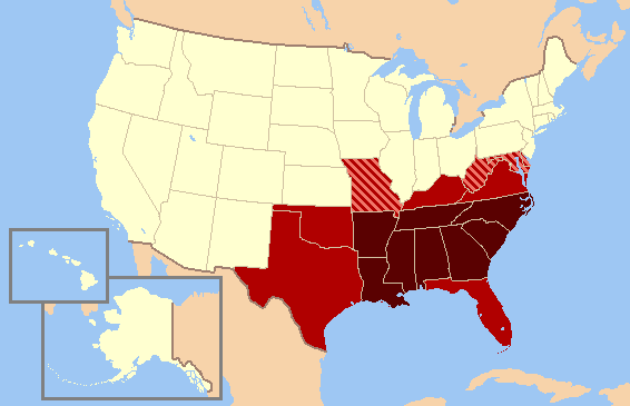
English: A map of the modern definition of the Southern United States, Oklahoma red.
|
| Дата | (UTC) |
| Крыніца |
|
| Аўтар |
| This is a retouched picture, which means that it has been digitally altered from its original version. Modifications: Due to consensus of Oklahoma as usually included in the south, the color has been changed.. The original can be viewed here: US map-South Modern.png:
|
Я, уладальнік аўтарскіх правоў на гэты твор, добраахвотна публікую яго на ўмовах наступнай ліцэнзіі:

|
Дазваляецца капіяваць, распаўсюджваць і(або) мадыфікаваць гэты дакумент на ўмовах ліцэнзіі GNU FDL версіі 1.2 або навейшай, выдадзенай Фондам свабоднага праграмнага забеспячэння; без Нязменных раздзелаў, без тэкстаў Вокладак. Копія ліцэнзіі ёсць у раздзеле GNU Free Documentation License. |
| Гэты файл даступны па ліцэнзіі Creative Commons Пазначэнне аўтарства - На тых самых умовах 3.0 Непартаваная | ||
| ||
| Гэтая картка дададзеная ў якасці часткі абнаўлення ліцэнзіі GFDL. |
Журнал арыгінальнай загрузкі
This image is a derivative work of the following images:
- File:US map-South Modern.png licensed with GFDL
- 2007-07-15T15:01:30Z Lecter 572x371 (13768 Bytes) {{Information |Description= Based on GNU [[Image:US map-South.PNG]] |Source= [http://en.wikipedia.org/wiki/Image:US map-South Modern.png] |Date= |Author= [http://en.wikipedia.org/wiki/User:AstroAstrokey44 User:Astrokey44] |Permiss
Uploaded with derivativeFX
Гісторыя файла
Націснуць на даце з часам, каб паказаць файл, якім ён тады быў.
| Дата і час | Драбніца | Памеры | Удзельнік | Тлумачэнне | |
|---|---|---|---|---|---|
| актуальн. | 01:24, 14 чэрвеня 2010 | | 566 × 365 (6 KB) | Ras67 | cropped |
| 05:46, 1 сакавіка 2009 |  | 572 × 371 (13 KB) | Clark3934 | {{Information |Description=A map of the modern definition of the Southern United States. |Source=*File:US_map-South_Modern.png |Date=2009-03-01 02:44 (UTC) |Author=*File:US_map-South_Modern.png: [http://en.wikipedia.org/wiki/User:Astrokey44 Us |
Выкарыстанне файла
Наступная 1 старонка выкарыстоўвае гэты файл:
Глабальнае выкарыстанне файла
Гэты файл выкарыстоўваецца ў наступных вікі:
- Выкарыстанне ў br.wikipedia.org
- Выкарыстанне ў ca.wikipedia.org
- Выкарыстанне ў de.wiktionary.org
- Выкарыстанне ў en.wikipedia.org
- Выкарыстанне ў en.wikivoyage.org
- Выкарыстанне ў fa.wikipedia.org
- Выкарыстанне ў fr.wikipedia.org
- Выкарыстанне ў hr.wikipedia.org
- Выкарыстанне ў id.wikipedia.org
- Выкарыстанне ў ja.wikipedia.org
- Выкарыстанне ў ka.wikipedia.org
- Выкарыстанне ў la.wikipedia.org
- Выкарыстанне ў ms.wikipedia.org
- Выкарыстанне ў nn.wikipedia.org
- Выкарыстанне ў no.wikipedia.org
- Выкарыстанне ў pt.wikipedia.org
- Выкарыстанне ў sh.wikipedia.org
- Выкарыстанне ў sr.wikipedia.org
- Выкарыстанне ў vi.wikipedia.org