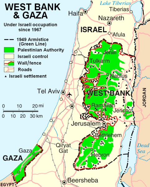
Файл:West Bank & Gaza Map 2007 (Settlements).png

Памер папярэдняга прагляду: 482 × 599 пікселяў. Іншыя разрозненні: 193 × 240 пікселяў | 386 × 480 пікселяў | 780 × 970 пікселяў.
Арыгінальны файл (780 × 970 кропак, аб’ём файла: 86 KB, тып MIME: image/png)
Гісторыя файла
Націснуць на даце з часам, каб паказаць файл, якім ён тады быў.
| Дата і час | Драбніца | Памеры | Удзельнік | Тлумачэнне | |
|---|---|---|---|---|---|
| актуальн. | 01:55, 30 кастрычніка 2013 |  | 780 × 970 (86 KB) | Scott | Correct capitalization in legend. |
| 01:54, 30 кастрычніка 2013 |  | 780 × 970 (86 KB) | Scott | Correct capitalization in legend. | |
| 09:21, 12 студзеня 2009 |  | 780 × 970 (105 KB) | HowardMorland | Replace .gif file with identical .png file <!--{{ImageUpload|basic}}--> |
Выкарыстанне файла
Няма старонак, якія выкарыстоўваюць гэты файл.
Глабальнае выкарыстанне файла
Гэты файл выкарыстоўваецца ў наступных вікі:
- Выкарыстанне ў am.wikipedia.org
- Выкарыстанне ў ar.wikipedia.org
- Выкарыстанне ў ast.wikipedia.org
- Выкарыстанне ў azb.wikipedia.org
- Выкарыстанне ў bg.wikipedia.org
- Выкарыстанне ў ca.wikipedia.org
- Выкарыстанне ў ckb.wikipedia.org
- Выкарыстанне ў cs.wikipedia.org
- Выкарыстанне ў cy.wikipedia.org
- Выкарыстанне ў da.wikipedia.org
- Выкарыстанне ў de.wikipedia.org
- Выкарыстанне ў de.wikinews.org
- Выкарыстанне ў de.wikivoyage.org
- Выкарыстанне ў en.wikipedia.org
- Talk:List of ongoing armed conflicts
- User:Timeshifter/Userboxes
- User:Gimmetrow/test
- User:Gimmetrow/test2
- User:Keizers
- Talk:Jerusalem/Archive 15
- Talk:Palestinian National Authority/Archive 2
- Wikipedia:Top 25 Report/July 13 to 19, 2014
- Wikipedia:Top 25 Report/July 20 to 26, 2014
- Wikipedia:Top 25 Report/July 27 to August 2, 2014
- Talk:State of Palestine/Archive 12
- User:Timeshifter/Userboxes/Palestine: Peace Not Apartheid. By Jimmy Carter
- User:Dare2Leap/info
- User:Timeshifter/Archive 2
- Wikipedia talk:WikiProject Israel Palestine Collaboration/Archive 9
- Выкарыстанне ў en.wikinews.org
- Выкарыстанне ў eo.wikipedia.org
- Выкарыстанне ў es.wikipedia.org
- Выкарыстанне ў eu.wikipedia.org
- Выкарыстанне ў fa.wikipedia.org
- Выкарыстанне ў fi.wikipedia.org
- Выкарыстанне ў fo.wikipedia.org
- Выкарыстанне ў fr.wikipedia.org
Паказаць глабальнае выкарыстанне гэтага файла.