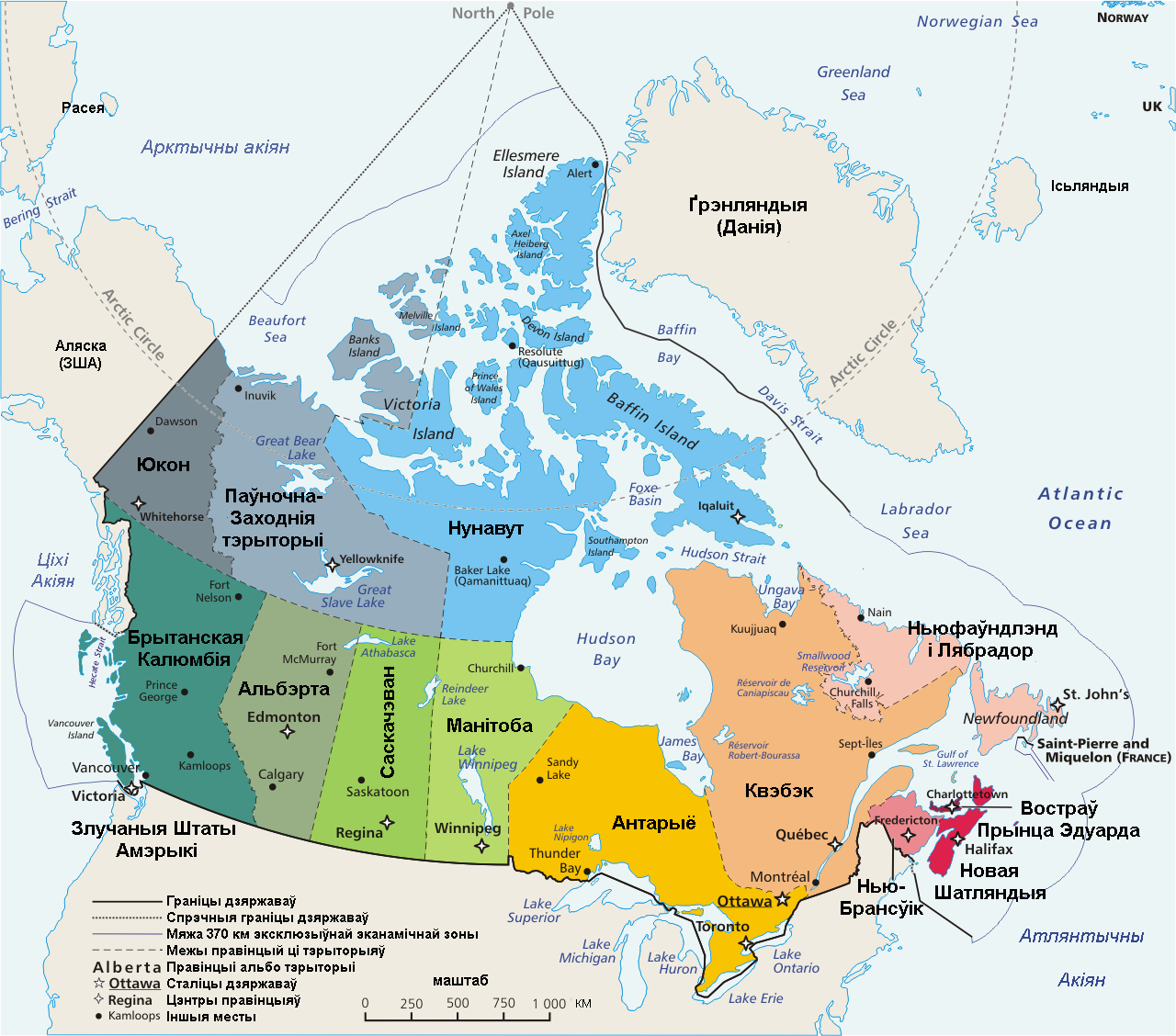
Файл:Map Canada political-geo-be-x-old.png
Памер папярэдняга прагляду: 680 × 599 пікселяў. Іншыя разрозненні: 272 × 240 пікселяў | 545 × 480 пікселяў | 872 × 768 пікселяў | 1 162 × 1 024 пікселяў | 1 280 × 1 128 пікселяў.
Арыгінальны файл (1 280 × 1 128 кропак, аб’ём файла: 401 KB, тып MIME: image/png)
| Апісанне | Map: Canada – geopolitical Drawn and adapted by E Pluribus Anthony from Atlas of Canada Edited by en:User:Heqs/en:User:Cogito ergo sumo to show disputed nature of Canada's marine international boundary claims; see en:Canada-United_States_border#Remaining_boundary_disputes; further edited by Bosonic dressing to reflect agreed maritime boundary between Canada and Greenland/Denmark: see http://www.dur.ac.uk/resources/ibru/arctic.pdf |
| Дата | (UTC) |
| Крыніца | |
| Аўтар |
Later versions were uploaded by AThing, Heqs, Cogito ergo sumo at en.wikipedia.
|
| This is a retouched picture, which means that it has been digitally altered from its original version. Modifications: translate to be-x-old language. The original can be viewed here: Map Canada political-geo.png:
|
Я, уладальнік аўтарскіх правоў на гэты твор, добраахвотна публікую яго на ўмовах наступнай ліцэнзіі:
| |
Гэты твор быў перададзены ў грамадскі набытак яго аутарам, Example, at the [[::|англійская Вікіпедыя]] project. Дазвол сапраўдны для ўсяго свету. In case this is not legally possible: |
Журнал арыгінальнай загрузкі
This image is a derivative work of the following images:
- File:Map_Canada_political-geo.png licensed with PD-user-w
- 2008-11-08T07:37:02Z Bosonic dressing 1280x1128 (504253 Bytes) {{Information |Description=Map of Canada, revised to reflect agreed border with Greenland/Denmark, per http://www.dur.ac.uk/resources/ibru/arctic.pdf |Source= |Date=8 November 2008 |Author=E Pluribus Anthony, et al |Permissio
- 2008-11-08T07:33:47Z Bosonic dressing 1280x1297 (541382 Bytes) {{Information |Description=Map of Canada, revised to reflect agreed border with Greenland/Denamrk, per http://www.dur.ac.uk/resources/ibru/arctic.pdf |Source= |Date=8 November 2008 |Author=E Pluribus Anthony, et al |Permissio
- 2007-06-15T19:54:14Z PMG 1280x1128 (508303 Bytes) {{Information |Description=Map: [[:en:Canada]] – geopolitical Drawn and adapted by [[:en:User:E Pluribus Anthony|E Pluribus Anthony]] from [http://atlas.gc.ca/site/english/maps/reference/national/can_political_e Atlas of C
Uploaded with derivativeFX
Гісторыя файла
Націснуць на даце з часам, каб паказаць файл, якім ён тады быў.
| Дата і час | Драбніца | Памеры | Удзельнік | Тлумачэнне | |
|---|---|---|---|---|---|
| актуальн. | 22:26, 6 лютага 2011 | | 1 280 × 1 128 (401 KB) | Vasyl` Babych | {{Information |Description=Map: Canada – geopolitical Drawn and adapted by E Pluribus Anthony from [http://atlas.gc.ca/site/english/maps/reference/national/can_political_e Atlas of Canada] Edited by [[:en:User:Heqs] |
Выкарыстанне файла
Наступныя 2 старонкі выкарыстоўваюць гэты файл:
Глабальнае выкарыстанне файла
Гэты файл выкарыстоўваецца ў наступных вікі:
- Выкарыстанне ў be-tarask.wikipedia.org