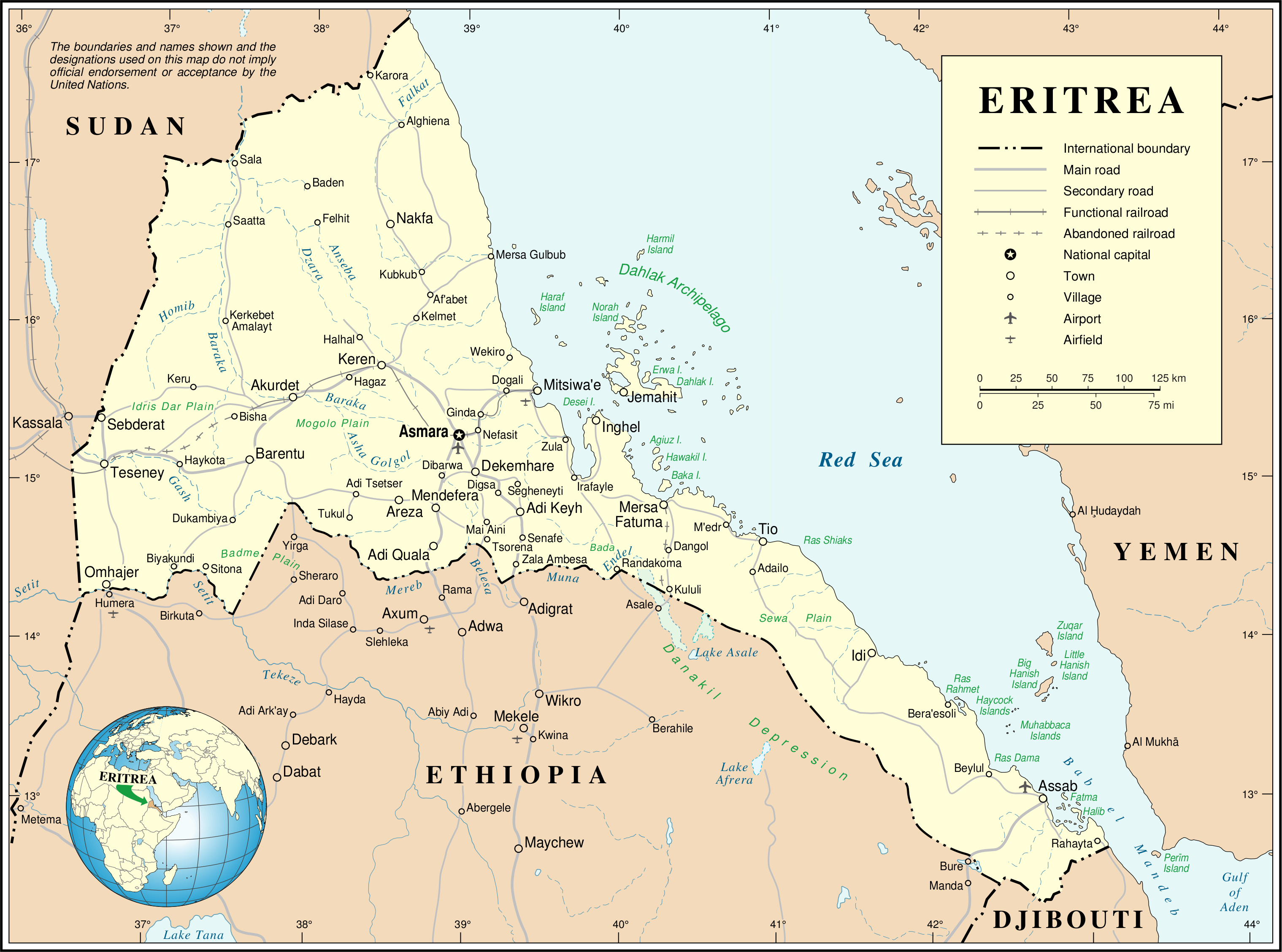
Файл:Un-eritrea.png
Арыгінальны файл (3 038 × 2 257 кропак, аб’ём файла: 1,26 MB, тып MIME: image/png)

|
This map image could be re-created using vector graphics as an SVG file. This has several advantages; see Commons:Media for cleanup for more information. If an SVG form of this image is available, please upload it and afterwards replace this template with
{{vector version available|new image name}}.
It is recommended to name the SVG file “Un-eritrea.svg”—then the template Vector version available (or Vva) does not need the new image name parameter. |
| This image is a map derived from a United Nations map.
Unless stated otherwise, UN maps are to be considered in the public domain. This applies worldwide. UN maps are, in principle, open source material and you can use them in your work or for making your own map. UN requests however that you delete the UN name, logo and reference number upon any modification to the map. Content of your map will be your responsibility. You can state in your publication, if you wish, something like: based on UN map … (map name, map number, revision number and date). See: Geospatial Information Section. And: Geospatial, location data for a better world. |
 |
Гісторыя файла
Націснуць на даце з часам, каб паказаць файл, якім ён тады быў.
| Дата і час | Драбніца | Памеры | Удзельнік | Тлумачэнне | |
|---|---|---|---|---|---|
| актуальн. | 03:57, 24 кастрычніка 2007 | | 3 038 × 2 257 (1,26 MB) | Jeroen | {{UN map}} Category:Maps of Eritrea |
Выкарыстанне файла
Наступная 1 старонка выкарыстоўвае гэты файл:
Глабальнае выкарыстанне файла
Гэты файл выкарыстоўваецца ў наступных вікі:
- Выкарыстанне ў ar.wikipedia.org
- Выкарыстанне ў avk.wikipedia.org
- Выкарыстанне ў az.wikipedia.org
- Выкарыстанне ў ca.wikipedia.org
- Выкарыстанне ў ckb.wikipedia.org
- Выкарыстанне ў cs.wikipedia.org
- Выкарыстанне ў de.wikipedia.org
- Выкарыстанне ў en.wikipedia.org
- Выкарыстанне ў en.wiktionary.org
- Выкарыстанне ў es.wikipedia.org
- Выкарыстанне ў fa.wikipedia.org
- Выкарыстанне ў fi.wikipedia.org
- Выкарыстанне ў fr.wikipedia.org
- Выкарыстанне ў ig.wikipedia.org
- Выкарыстанне ў it.wikipedia.org
- Выкарыстанне ў ja.wikipedia.org
- Выкарыстанне ў ka.wikipedia.org
- Выкарыстанне ў mzn.wikipedia.org
- Выкарыстанне ў nl.wikipedia.org
- Выкарыстанне ў no.wikipedia.org
- Выкарыстанне ў pa.wikipedia.org
- Выкарыстанне ў pl.wikipedia.org
- Выкарыстанне ў pl.wiktionary.org
Паказаць глабальнае выкарыстанне гэтага файла.